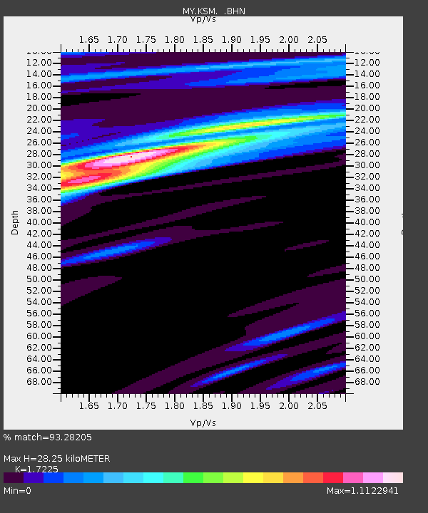
KSM Kuching - Earthquake Result Viewer

Earthquake location: New Ireland Region, P.N.G.
Earthquake latitude/longitude: -3.6/151.0
Earthquake time(UTC): 2007/06/18 (169) 06:18:48 GMT
Earthquake Depth: 26 km
Earthquake Magnitude: 5.7 MB, 6.2 MS, 6.3 MW, 6.1 MW
Earthquake Catalog/Contributor: WHDF/NEIC
Network: MY Malaysian National Seismic Network
Station: KSM Kuching
Lat/Lon: 1.47 N/110.31 E
Elevation: 66 m
Distance: 40.9 deg
Az: 276.341 deg
Baz: 97.111 deg
Ray Param: 0.07406321
Estimated Moho Depth: 28.25 km
Estimated Crust Vp/Vs: 1.72
Assumed Crust Vp: 6.468 km/s
Estimated Crust Vs: 3.755 km/s
Estimated Crust Poisson's Ratio: 0.25
Radial Match: 93.28205 %
Radial Bump: 341
Transverse Match: 81.27809 %
Transverse Bump: 400
SOD ConfigId: 2564
Insert Time: 2010-03-09 03:36:49.832 +0000
GWidth: 2.5
Max Bumps: 400
Tol: 0.001

Signal To Noise

ChannelStoNSTALTA
MY:KSM: :BHN:20070618T06:25:57.868014Z1.92235361.9495015E-71.0141222E-7
MY:KSM: :BHE:20070618T06:25:57.868014Z2.9537163.361622E-71.1380992E-7
MY:KSM: :BHZ:20070618T06:25:57.868014Z8.3882959.115141E-71.0866501E-7
Arrivals
Ps3.4 SECOND
PpPs11 SECOND
PsPs/PpSs14 SECOND