You are here: Home > Network List > US - United States National Seismic Network Stations List
> Station HAWA Hanford, Washington, USA > Earthquake Result Viewer
HAWA Hanford, Washington, USA - Earthquake Result Viewer
*The percent match for this event was below the threshold and hence no stack was calculated.
| Earthquake location: |
Off Coast Of Central Chile |
| Earthquake latitude/longitude: |
-34.6/-73.1 |
| Earthquake time(UTC): |
2020/11/22 (327) 00:54:56 GMT |
| Earthquake Depth: |
20 km |
| Earthquake Magnitude: |
6.1 Mww |
| Earthquake Catalog/Contributor: |
NEIC PDE/us |
|
| Network: |
US United States National Seismic Network |
| Station: |
HAWA Hanford, Washington, USA |
| Lat/Lon: |
46.39 N/119.53 W |
| Elevation: |
364 m |
|
| Distance: |
90.9 deg |
| Az: |
329.881 deg |
| Baz: |
143.278 deg |
| Ray Param: |
$rayparam |
*The percent match for this event was below the threshold and hence was not used in the summary stack. |
|
| Radial Match: |
49.422855 % |
| Radial Bump: |
400 |
| Transverse Match: |
49.069168 % |
| Transverse Bump: |
380 |
| SOD ConfigId: |
23341671 |
| Insert Time: |
2020-12-06 02:19:20.344 +0000 |
| GWidth: |
2.5 |
| Max Bumps: |
400 |
| Tol: |
0.001 |
|
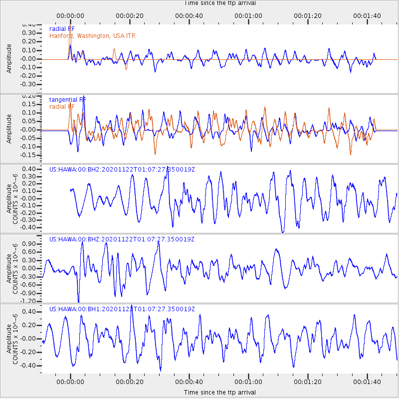
Signal To Noise
| Channel | StoN | STA | LTA |
| US:HAWA:00:BHZ:20201122T01:07:27.350019Z | 2.3485844 | 5.125583E-7 | 2.1824137E-7 |
| US:HAWA:00:BH1:20201122T01:07:27.350019Z | 2.2505386 | 2.623901E-7 | 1.1658991E-7 |
| US:HAWA:00:BH2:20201122T01:07:27.350019Z | 1.6140075 | 2.3438996E-7 | 1.4522234E-7 |
| Arrivals |
| Ps | |
| PpPs | |
| PsPs/PpSs | |


