You are here: Home > Network List > UU - University of Utah Regional Network Stations List
> Station FOR1 Milford Southwest, UT, USA > Earthquake Result Viewer
FOR1 Milford Southwest, UT, USA - Earthquake Result Viewer
| Earthquake location: |
Off Coast Of Central Chile |
| Earthquake latitude/longitude: |
-34.6/-73.1 |
| Earthquake time(UTC): |
2020/11/22 (327) 00:54:56 GMT |
| Earthquake Depth: |
20 km |
| Earthquake Magnitude: |
6.1 Mww |
| Earthquake Catalog/Contributor: |
NEIC PDE/us |
|
| Network: |
UU University of Utah Regional Network |
| Station: |
FOR1 Milford Southwest, UT, USA |
| Lat/Lon: |
38.37 N/113.09 W |
| Elevation: |
1642 m |
|
| Distance: |
81.6 deg |
| Az: |
329.266 deg |
| Baz: |
147.575 deg |
| Ray Param: |
0.04749311 |
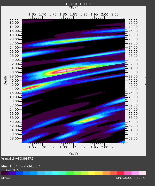
| Estimated Moho Depth: |
34.75 km |
| Estimated Crust Vp/Vs: |
1.82 |
| Assumed Crust Vp: |
6.276 km/s |
| Estimated Crust Vs: |
3.458 km/s |
| Estimated Crust Poisson's Ratio: |
0.28 |
|
| Radial Match: |
83.86472 % |
| Radial Bump: |
400 |
| Transverse Match: |
66.622635 % |
| Transverse Bump: |
400 |
| SOD ConfigId: |
23341671 |
| Insert Time: |
2020-12-06 02:20:17.439 +0000 |
| GWidth: |
2.5 |
| Max Bumps: |
400 |
| Tol: |
0.001 |
|

Signal To Noise
| Channel | StoN | STA | LTA |
| UU:FOR1:01:HHZ:20201122T01:06:41.679975Z | 5.111175 | 2.5763976E-8 | 5.0407145E-9 |
| UU:FOR1:01:HHN:20201122T01:06:41.679975Z | 4.247264 | 9.937144E-9 | 2.339658E-9 |
| UU:FOR1:01:HHE:20201122T01:06:41.679975Z | 3.2539914 | 7.599866E-9 | 2.3355518E-9 |
| Arrivals |
| Ps | 4.6 SECOND |
| PpPs | 15 SECOND |
| PsPs/PpSs | 20 SECOND |


