You are here: Home > Network List > UU - University of Utah Regional Network Stations List
> Station HMU Henry Mountain, UT, USA > Earthquake Result Viewer
HMU Henry Mountain, UT, USA - Earthquake Result Viewer
| Earthquake location: |
Off Coast Of Central Chile |
| Earthquake latitude/longitude: |
-34.6/-73.1 |
| Earthquake time(UTC): |
2020/11/22 (327) 00:54:56 GMT |
| Earthquake Depth: |
20 km |
| Earthquake Magnitude: |
6.1 Mww |
| Earthquake Catalog/Contributor: |
NEIC PDE/us |
|
| Network: |
UU University of Utah Regional Network |
| Station: |
HMU Henry Mountain, UT, USA |
| Lat/Lon: |
37.94 N/110.74 W |
| Elevation: |
2430 m |
|
| Distance: |
80.2 deg |
| Az: |
330.638 deg |
| Baz: |
149.239 deg |
| Ray Param: |
0.048415482 |
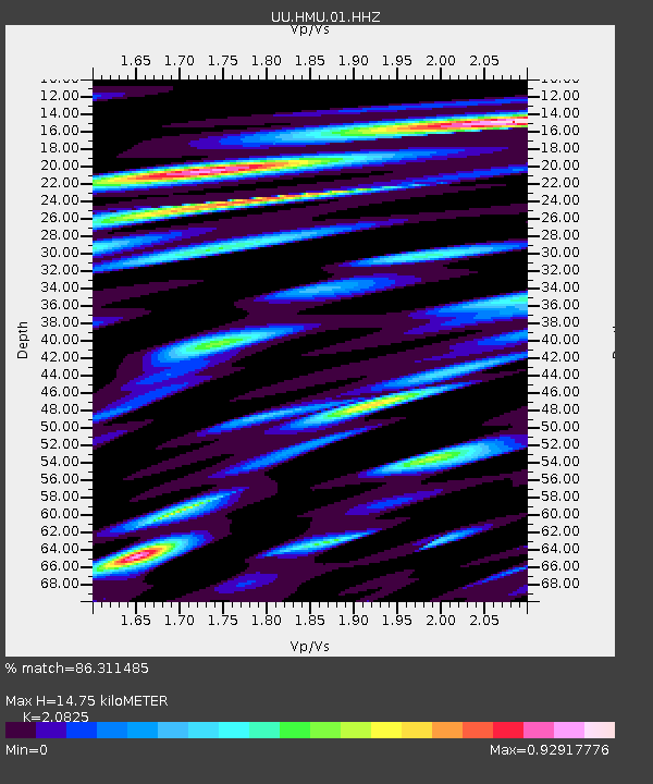
| Estimated Moho Depth: |
14.75 km |
| Estimated Crust Vp/Vs: |
2.08 |
| Assumed Crust Vp: |
6.247 km/s |
| Estimated Crust Vs: |
3.0 km/s |
| Estimated Crust Poisson's Ratio: |
0.35 |
|
| Radial Match: |
86.311485 % |
| Radial Bump: |
400 |
| Transverse Match: |
76.857445 % |
| Transverse Bump: |
400 |
| SOD ConfigId: |
23341671 |
| Insert Time: |
2020-12-06 02:20:26.221 +0000 |
| GWidth: |
2.5 |
| Max Bumps: |
400 |
| Tol: |
0.001 |
|

Signal To Noise
| Channel | StoN | STA | LTA |
| UU:HMU:01:HHZ:20201122T01:06:34.567975Z | 18.124918 | 4.6553538E-8 | 2.5684825E-9 |
| UU:HMU:01:HHN:20201122T01:06:34.567975Z | 4.215727 | 1.1812864E-8 | 2.8020941E-9 |
| UU:HMU:01:HHE:20201122T01:06:34.567975Z | 5.615686 | 1.2747114E-8 | 2.269912E-9 |
| Arrivals |
| Ps | 2.6 SECOND |
| PpPs | 7.1 SECOND |
| PsPs/PpSs | 9.7 SECOND |


