You are here: Home > Network List > UU - University of Utah Regional Network Stations List
> Station LIUT Lila Canyon, UT, USA > Earthquake Result Viewer
LIUT Lila Canyon, UT, USA - Earthquake Result Viewer
| Earthquake location: |
Off Coast Of Central Chile |
| Earthquake latitude/longitude: |
-34.6/-73.1 |
| Earthquake time(UTC): |
2020/11/22 (327) 00:54:56 GMT |
| Earthquake Depth: |
20 km |
| Earthquake Magnitude: |
6.1 Mww |
| Earthquake Catalog/Contributor: |
NEIC PDE/us |
|
| Network: |
UU University of Utah Regional Network |
| Station: |
LIUT Lila Canyon, UT, USA |
| Lat/Lon: |
39.42 N/110.33 W |
| Elevation: |
2178 m |
|
| Distance: |
81.3 deg |
| Az: |
331.686 deg |
| Baz: |
149.667 deg |
| Ray Param: |
0.047652084 |
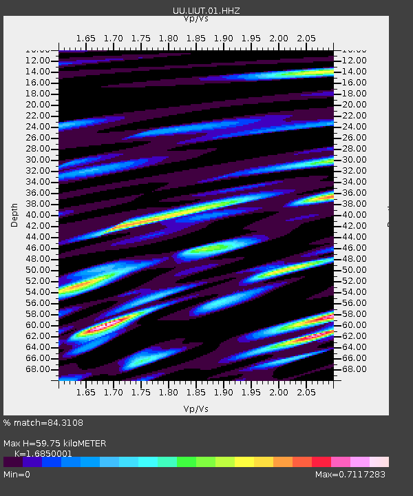
| Estimated Moho Depth: |
59.75 km |
| Estimated Crust Vp/Vs: |
1.69 |
| Assumed Crust Vp: |
6.207 km/s |
| Estimated Crust Vs: |
3.684 km/s |
| Estimated Crust Poisson's Ratio: |
0.23 |
|
| Radial Match: |
84.3108 % |
| Radial Bump: |
400 |
| Transverse Match: |
77.517296 % |
| Transverse Bump: |
400 |
| SOD ConfigId: |
23341671 |
| Insert Time: |
2020-12-06 02:20:30.004 +0000 |
| GWidth: |
2.5 |
| Max Bumps: |
400 |
| Tol: |
0.001 |
|

Signal To Noise
| Channel | StoN | STA | LTA |
| UU:LIUT:01:HHZ:20201122T01:06:40.489972Z | 7.2315264 | 3.211866E-8 | 4.4414774E-9 |
| UU:LIUT:01:HHN:20201122T01:06:40.489972Z | 1.7612165 | 8.255564E-9 | 4.6874216E-9 |
| UU:LIUT:01:HHE:20201122T01:06:40.489972Z | 2.4866161 | 7.2819093E-9 | 2.9284413E-9 |
| Arrivals |
| Ps | 6.8 SECOND |
| PpPs | 25 SECOND |
| PsPs/PpSs | 32 SECOND |


