You are here: Home > Network List > MY - Malaysian National Seismic Network Stations List
> Station KSM Kuching > Earthquake Result Viewer
KSM Kuching - Earthquake Result Viewer
| Earthquake location: |
Near S. Coast Of Honshu, Japan |
| Earthquake latitude/longitude: |
33.2/137.9 |
| Earthquake time(UTC): |
2009/08/09 (221) 10:55:55 GMT |
| Earthquake Depth: |
297 km |
| Earthquake Magnitude: |
6.5 MB, 7.1 MW, 7.1 MW |
| Earthquake Catalog/Contributor: |
WHDF/NEIC |
|
| Network: |
MY Malaysian National Seismic Network |
| Station: |
KSM Kuching |
| Lat/Lon: |
1.47 N/110.31 E |
| Elevation: |
66 m |
|
| Distance: |
40.8 deg |
| Az: |
225.175 deg |
| Baz: |
36.519 deg |
| Ray Param: |
0.0729355 |
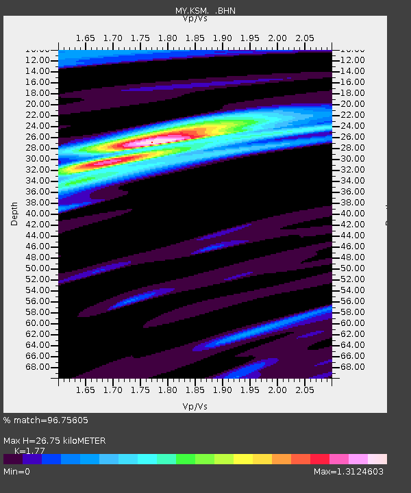
| Estimated Moho Depth: |
26.75 km |
| Estimated Crust Vp/Vs: |
1.77 |
| Assumed Crust Vp: |
6.468 km/s |
| Estimated Crust Vs: |
3.654 km/s |
| Estimated Crust Poisson's Ratio: |
0.27 |
|
| Radial Match: |
96.75605 % |
| Radial Bump: |
325 |
| Transverse Match: |
87.97672 % |
| Transverse Bump: |
400 |
| SOD ConfigId: |
2622 |
| Insert Time: |
2010-03-09 03:37:20.209 +0000 |
| GWidth: |
2.5 |
| Max Bumps: |
400 |
| Tol: |
0.001 |
|

Signal To Noise
| Channel | StoN | STA | LTA |
| MY:KSM: :BHN:20090809T11:02:38.319015Z | 175.96056 | 1.631328E-5 | 9.2709875E-8 |
| MY:KSM: :BHE:20090809T11:02:38.319015Z | 93.935036 | 5.669715E-6 | 6.035783E-8 |
| MY:KSM: :BHZ:20090809T11:02:38.319015Z | 88.43363 | 5.75341E-6 | 6.505907E-8 |
| Arrivals |
| Ps | 3.4 SECOND |
| PpPs | 11 SECOND |
| PsPs/PpSs | 14 SECOND |


