You are here: Home > Network List > MY - Malaysian National Seismic Network Stations List
> Station KSM Kuching > Earthquake Result Viewer
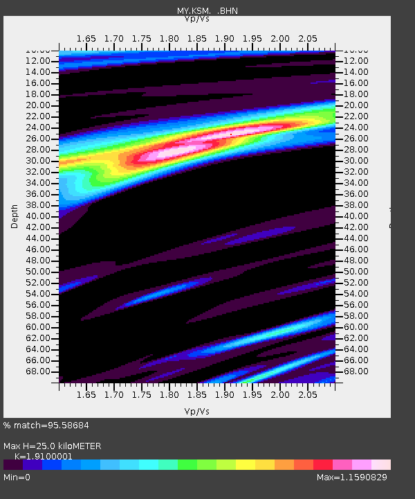
KSM Kuching - Earthquake Result Viewer
| Earthquake location: |
Southeast Of Honshu, Japan |
| Earthquake latitude/longitude: |
32.8/140.4 |
| Earthquake time(UTC): |
2009/08/12 (224) 22:48:51 GMT |
| Earthquake Depth: |
53 km |
| Earthquake Magnitude: |
6.2 MB, 6.6 MW, 6.6 MW |
| Earthquake Catalog/Contributor: |
WHDF/NEIC |
|
| Network: |
MY Malaysian National Seismic Network |
| Station: |
KSM Kuching |
| Lat/Lon: |
1.47 N/110.31 E |
| Elevation: |
66 m |
|
| Distance: |
42.1 deg |
| Az: |
228.389 deg |
| Baz: |
39.032 deg |
| Ray Param: |
0.07323991 |
| Estimated Moho Depth: |
25.0 km |
| Estimated Crust Vp/Vs: |
1.91 |
| Assumed Crust Vp: |
6.468 km/s |
| Estimated Crust Vs: |
3.386 km/s |
| Estimated Crust Poisson's Ratio: |
0.31 |
|
| Radial Match: |
95.58684 % |
| Radial Bump: |
301 |
| Transverse Match: |
88.80085 % |
| Transverse Bump: |
400 |
| SOD ConfigId: |
2622 |
| Insert Time: |
2010-03-09 03:37:24.929 +0000 |
| GWidth: |
2.5 |
| Max Bumps: |
400 |
| Tol: |
0.001 |
|

Signal To Noise
| Channel | StoN | STA | LTA |
| MY:KSM: :BHN:20090812T22:56:07.770006Z | 21.683548 | 2.0149234E-6 | 9.292407E-8 |
| MY:KSM: :BHE:20090812T22:56:07.770006Z | 12.289607 | 7.2594463E-7 | 5.9069798E-8 |
| MY:KSM: :BHZ:20090812T22:56:07.770006Z | 11.00014 | 7.360958E-7 | 6.691695E-8 |
| Arrivals |
| Ps | 3.7 SECOND |
| PpPs | 11 SECOND |
| PsPs/PpSs | 14 SECOND |


