You are here: Home > Network List > WY - Yellowstone Wyoming Seismic Network Stations List
> Station YHH Holmes Hill, YNP, WY, USA > Earthquake Result Viewer
YHH Holmes Hill, YNP, WY, USA - Earthquake Result Viewer
| Earthquake location: |
Off Coast Of Central Chile |
| Earthquake latitude/longitude: |
-34.6/-73.1 |
| Earthquake time(UTC): |
2020/11/22 (327) 00:54:56 GMT |
| Earthquake Depth: |
20 km |
| Earthquake Magnitude: |
6.1 Mww |
| Earthquake Catalog/Contributor: |
NEIC PDE/us |
|
| Network: |
WY Yellowstone Wyoming Seismic Network |
| Station: |
YHH Holmes Hill, YNP, WY, USA |
| Lat/Lon: |
44.79 N/110.85 W |
| Elevation: |
2717 m |
|
| Distance: |
86.2 deg |
| Az: |
334.073 deg |
| Baz: |
149.576 deg |
| Ray Param: |
0.044243004 |
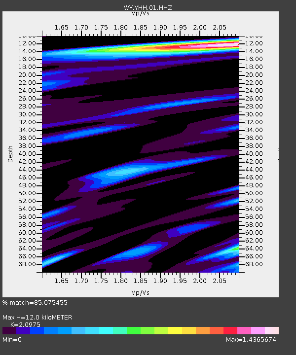
| Estimated Moho Depth: |
12.0 km |
| Estimated Crust Vp/Vs: |
2.10 |
| Assumed Crust Vp: |
6.35 km/s |
| Estimated Crust Vs: |
3.027 km/s |
| Estimated Crust Poisson's Ratio: |
0.35 |
|
| Radial Match: |
85.075455 % |
| Radial Bump: |
400 |
| Transverse Match: |
71.94105 % |
| Transverse Bump: |
400 |
| SOD ConfigId: |
23341671 |
| Insert Time: |
2020-12-06 02:22:49.818 +0000 |
| GWidth: |
2.5 |
| Max Bumps: |
400 |
| Tol: |
0.001 |
|
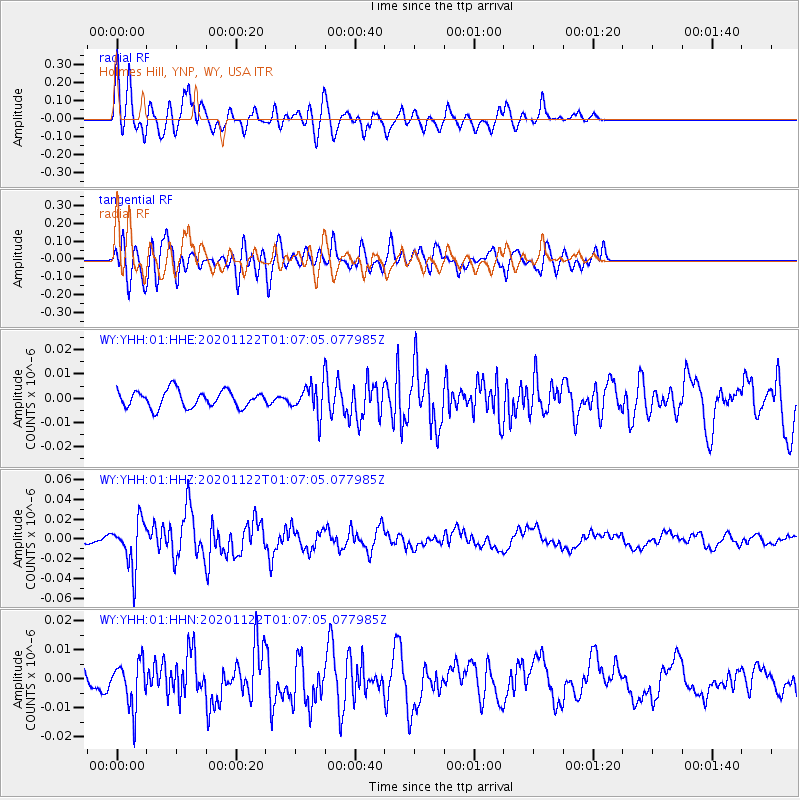
Signal To Noise
| Channel | StoN | STA | LTA |
| WY:YHH:01:HHZ:20201122T01:07:05.077985Z | 5.778936 | 2.380743E-8 | 4.1196913E-9 |
| WY:YHH:01:HHN:20201122T01:07:05.077985Z | 1.6574824 | 7.994999E-9 | 4.8235806E-9 |
| WY:YHH:01:HHE:20201122T01:07:05.077985Z | 1.748181 | 6.02192E-9 | 3.4446777E-9 |
| Arrivals |
| Ps | 2.1 SECOND |
| PpPs | 5.7 SECOND |
| PsPs/PpSs | 7.9 SECOND |


