You are here: Home > Network List > CI - Caltech Regional Seismic Network Stations List
> Station MPM Manuel Prospect Mine, California, USA > Earthquake Result Viewer
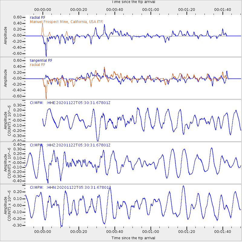
MPM Manuel Prospect Mine, California, USA - Earthquake Result Viewer
*The percent match for this event was below the threshold and hence no stack was calculated.
| Earthquake location: |
Fiji Islands Region |
| Earthquake latitude/longitude: |
-16.8/174.4 |
| Earthquake time(UTC): |
2020/11/22 (327) 05:18:37 GMT |
| Earthquake Depth: |
10 km |
| Earthquake Magnitude: |
5.5 Mww |
| Earthquake Catalog/Contributor: |
NEIC PDE/us |
|
| Network: |
CI Caltech Regional Seismic Network |
| Station: |
MPM Manuel Prospect Mine, California, USA |
| Lat/Lon: |
36.06 N/117.49 W |
| Elevation: |
185 m |
|
| Distance: |
83.0 deg |
| Az: |
49.224 deg |
| Baz: |
243.536 deg |
| Ray Param: |
$rayparam |
*The percent match for this event was below the threshold and hence was not used in the summary stack. |
|
| Radial Match: |
77.142715 % |
| Radial Bump: |
400 |
| Transverse Match: |
50.244022 % |
| Transverse Bump: |
400 |
| SOD ConfigId: |
23341671 |
| Insert Time: |
2020-12-06 06:24:47.301 +0000 |
| GWidth: |
2.5 |
| Max Bumps: |
400 |
| Tol: |
0.001 |
|
Signal To Noise
| Channel | StoN | STA | LTA |
| CI:MPM: :HHZ:20201122T05:30:31.67801Z | 1.8247854 | 2.5278658E-7 | 1.3852949E-7 |
| CI:MPM: :HHN:20201122T05:30:31.67801Z | 1.1730355 | 1.295889E-7 | 1.10473124E-7 |
| CI:MPM: :HHE:20201122T05:30:31.67801Z | 2.0850196 | 2.137564E-7 | 1.0252009E-7 |
| Arrivals |
| Ps | |
| PpPs | |
| PsPs/PpSs | |


