You are here: Home > Network List > TA - USArray Transportable Network (new EarthScope stations) Stations List
> Station G21K Allakaket, AK, USA > Earthquake Result Viewer
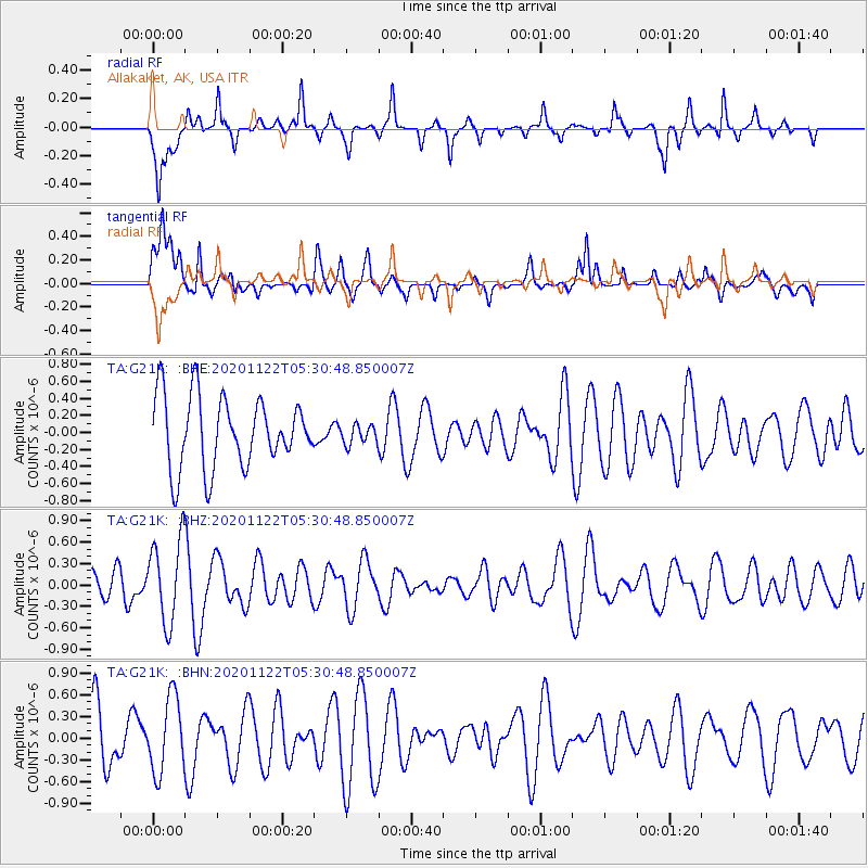
G21K Allakaket, AK, USA - Earthquake Result Viewer
*The percent match for this event was below the threshold and hence no stack was calculated.
| Earthquake location: |
Fiji Islands Region |
| Earthquake latitude/longitude: |
-16.8/174.4 |
| Earthquake time(UTC): |
2020/11/22 (327) 05:18:37 GMT |
| Earthquake Depth: |
10 km |
| Earthquake Magnitude: |
5.5 Mww |
| Earthquake Catalog/Contributor: |
NEIC PDE/us |
|
| Network: |
TA USArray Transportable Network (new EarthScope stations) |
| Station: |
G21K Allakaket, AK, USA |
| Lat/Lon: |
66.52 N/153.51 W |
| Elevation: |
446 m |
|
| Distance: |
86.4 deg |
| Az: |
12.302 deg |
| Baz: |
210.617 deg |
| Ray Param: |
$rayparam |
*The percent match for this event was below the threshold and hence was not used in the summary stack. |
|
| Radial Match: |
57.878162 % |
| Radial Bump: |
287 |
| Transverse Match: |
60.265533 % |
| Transverse Bump: |
400 |
| SOD ConfigId: |
23341671 |
| Insert Time: |
2020-12-06 06:29:37.434 +0000 |
| GWidth: |
2.5 |
| Max Bumps: |
400 |
| Tol: |
0.001 |
|
Signal To Noise
| Channel | StoN | STA | LTA |
| TA:G21K: :BHZ:20201122T05:30:48.850007Z | 1.7501012 | 5.820166E-7 | 3.3256168E-7 |
| TA:G21K: :BHN:20201122T05:30:48.850007Z | 1.3909782 | 5.205818E-7 | 3.7425588E-7 |
| TA:G21K: :BHE:20201122T05:30:48.850007Z | 0.27531996 | 1.13648625E-7 | 4.1278744E-7 |
| Arrivals |
| Ps | |
| PpPs | |
| PsPs/PpSs | |


