You are here: Home > Network List > US - United States National Seismic Network Stations List
> Station DGMT Dagmar, Montana, USA > Earthquake Result Viewer
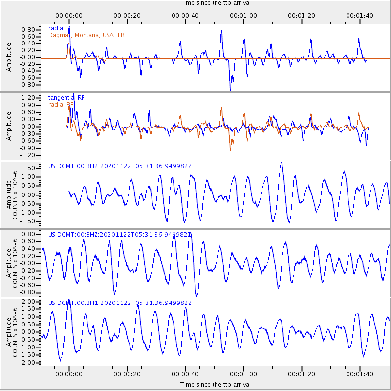
DGMT Dagmar, Montana, USA - Earthquake Result Viewer
*The percent match for this event was below the threshold and hence no stack was calculated.
| Earthquake location: |
Fiji Islands Region |
| Earthquake latitude/longitude: |
-16.8/174.4 |
| Earthquake time(UTC): |
2020/11/22 (327) 05:18:37 GMT |
| Earthquake Depth: |
10 km |
| Earthquake Magnitude: |
5.5 Mww |
| Earthquake Catalog/Contributor: |
NEIC PDE/us |
|
| Network: |
US United States National Seismic Network |
| Station: |
DGMT Dagmar, Montana, USA |
| Lat/Lon: |
48.47 N/104.20 W |
| Elevation: |
0.0 m |
|
| Distance: |
96.8 deg |
| Az: |
41.5 deg |
| Baz: |
252.506 deg |
| Ray Param: |
$rayparam |
*The percent match for this event was below the threshold and hence was not used in the summary stack. |
|
| Radial Match: |
55.896717 % |
| Radial Bump: |
400 |
| Transverse Match: |
57.799236 % |
| Transverse Bump: |
400 |
| SOD ConfigId: |
23341671 |
| Insert Time: |
2020-12-06 06:31:10.478 +0000 |
| GWidth: |
2.5 |
| Max Bumps: |
400 |
| Tol: |
0.001 |
|
Signal To Noise
| Channel | StoN | STA | LTA |
| US:DGMT:00:BHZ:20201122T05:31:36.949982Z | 1.4151069 | 3.5412762E-7 | 2.5024795E-7 |
| US:DGMT:00:BH1:20201122T05:31:36.949982Z | 2.2639587 | 1.2406938E-6 | 5.4801967E-7 |
| US:DGMT:00:BH2:20201122T05:31:36.949982Z | 2.3357031 | 8.390216E-7 | 3.5921587E-7 |
| Arrivals |
| Ps | |
| PpPs | |
| PsPs/PpSs | |


