You are here: Home > Network List > US - United States National Seismic Network Stations List
> Station MNTX Cornudas Mountains, Texas, USA > Earthquake Result Viewer
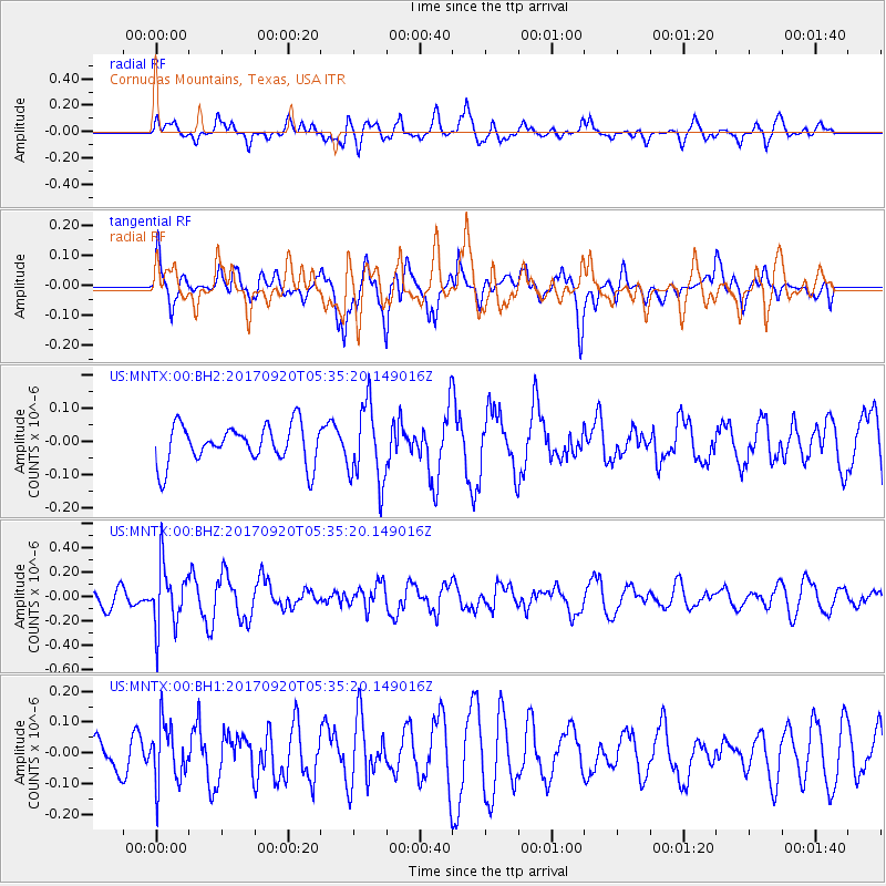
MNTX Cornudas Mountains, Texas, USA - Earthquake Result Viewer
*The percent match for this event was below the threshold and hence no stack was calculated.
| Earthquake location: |
Southern Peru |
| Earthquake latitude/longitude: |
-16.3/-71.3 |
| Earthquake time(UTC): |
2017/09/20 (263) 05:26:08 GMT |
| Earthquake Depth: |
93 km |
| Earthquake Magnitude: |
5.3 Mww |
| Earthquake Catalog/Contributor: |
NEIC PDE/us |
|
| Network: |
US United States National Seismic Network |
| Station: |
MNTX Cornudas Mountains, Texas, USA |
| Lat/Lon: |
31.70 N/105.38 W |
| Elevation: |
404 m |
|
| Distance: |
57.8 deg |
| Az: |
325.659 deg |
| Baz: |
140.534 deg |
| Ray Param: |
$rayparam |
*The percent match for this event was below the threshold and hence was not used in the summary stack. |
|
| Radial Match: |
60.40488 % |
| Radial Bump: |
400 |
| Transverse Match: |
65.88781 % |
| Transverse Bump: |
400 |
| SOD ConfigId: |
2341311 |
| Insert Time: |
2017-10-04 13:05:41.967 +0000 |
| GWidth: |
2.5 |
| Max Bumps: |
400 |
| Tol: |
0.001 |
|
Signal To Noise
| Channel | StoN | STA | LTA |
| US:MNTX:00:BHZ:20170920T05:35:20.149016Z | 2.6730685 | 2.5213285E-7 | 9.4323376E-8 |
| US:MNTX:00:BH1:20170920T05:35:20.149016Z | 1.1286457 | 9.4601894E-8 | 8.3818954E-8 |
| US:MNTX:00:BH2:20170920T05:35:20.149016Z | 2.0075006 | 1.16047566E-7 | 5.7806986E-8 |
| Arrivals |
| Ps | |
| PpPs | |
| PsPs/PpSs | |


