You are here: Home > Network List > US - United States National Seismic Network Stations List
> Station WMOK Wichita Mountains, Oklahoma, USA > Earthquake Result Viewer
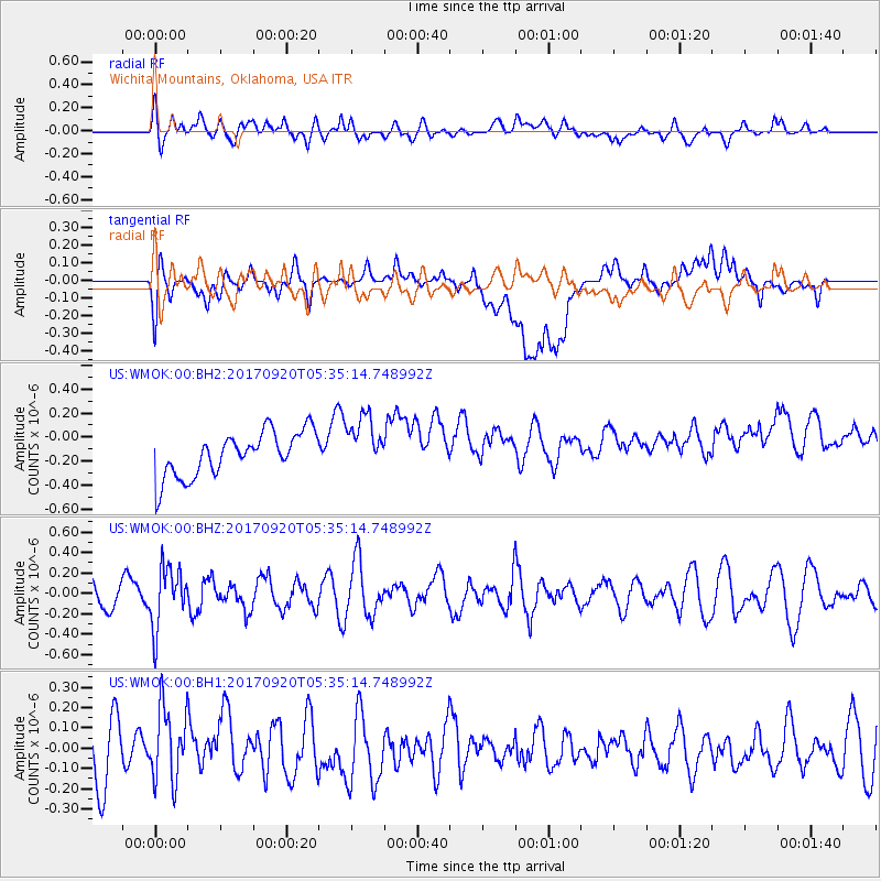
WMOK Wichita Mountains, Oklahoma, USA - Earthquake Result Viewer
*The percent match for this event was below the threshold and hence no stack was calculated.
| Earthquake location: |
Southern Peru |
| Earthquake latitude/longitude: |
-16.3/-71.3 |
| Earthquake time(UTC): |
2017/09/20 (263) 05:26:08 GMT |
| Earthquake Depth: |
93 km |
| Earthquake Magnitude: |
5.3 Mww |
| Earthquake Catalog/Contributor: |
NEIC PDE/us |
|
| Network: |
US United States National Seismic Network |
| Station: |
WMOK Wichita Mountains, Oklahoma, USA |
| Lat/Lon: |
34.74 N/98.78 W |
| Elevation: |
486 m |
|
| Distance: |
57.1 deg |
| Az: |
333.088 deg |
| Baz: |
148.14 deg |
| Ray Param: |
$rayparam |
*The percent match for this event was below the threshold and hence was not used in the summary stack. |
|
| Radial Match: |
45.099815 % |
| Radial Bump: |
400 |
| Transverse Match: |
36.55654 % |
| Transverse Bump: |
400 |
| SOD ConfigId: |
2341311 |
| Insert Time: |
2017-10-04 13:06:16.495 +0000 |
| GWidth: |
2.5 |
| Max Bumps: |
400 |
| Tol: |
0.001 |
|
Signal To Noise
| Channel | StoN | STA | LTA |
| US:WMOK:00:BHZ:20170920T05:35:14.748992Z | 2.1163409 | 2.9523562E-7 | 1.3950287E-7 |
| US:WMOK:00:BH1:20170920T05:35:14.748992Z | 1.3972988 | 1.8585868E-7 | 1.3301285E-7 |
| US:WMOK:00:BH2:20170920T05:35:14.748992Z | 1.2485025 | 2.2960256E-7 | 1.8390236E-7 |
| Arrivals |
| Ps | |
| PpPs | |
| PsPs/PpSs | |


