You are here: Home > Network List > TA - USArray Transportable Network (new EarthScope stations) Stations List
> Station I30M Mount Dempster, Yukon, CAN > Earthquake Result Viewer
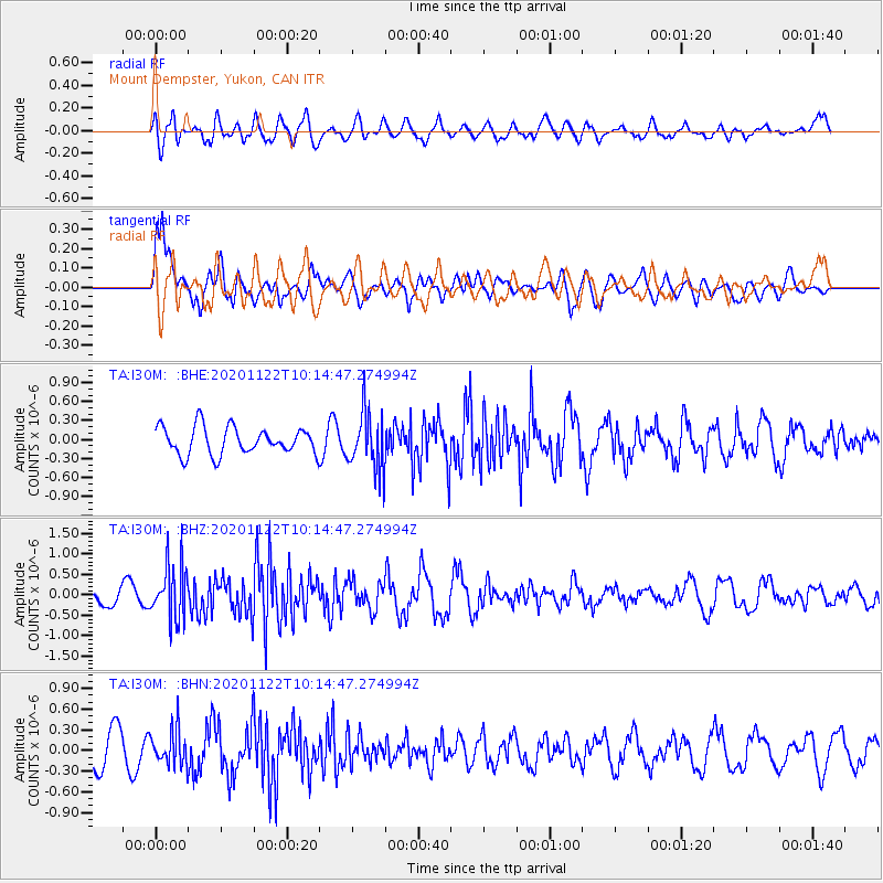
I30M Mount Dempster, Yukon, CAN - Earthquake Result Viewer
*The percent match for this event was below the threshold and hence no stack was calculated.
| Earthquake location: |
Near East Coast Of Honshu, Japan |
| Earthquake latitude/longitude: |
36.6/141.1 |
| Earthquake time(UTC): |
2020/11/22 (327) 10:05:54 GMT |
| Earthquake Depth: |
35 km |
| Earthquake Magnitude: |
5.5 Mww |
| Earthquake Catalog/Contributor: |
NEIC PDE/us |
|
| Network: |
TA USArray Transportable Network (new EarthScope stations) |
| Station: |
I30M Mount Dempster, Yukon, CAN |
| Lat/Lon: |
65.22 N/136.38 W |
| Elevation: |
1399 m |
|
| Distance: |
54.4 deg |
| Az: |
30.924 deg |
| Baz: |
281.028 deg |
| Ray Param: |
$rayparam |
*The percent match for this event was below the threshold and hence was not used in the summary stack. |
|
| Radial Match: |
42.117435 % |
| Radial Bump: |
400 |
| Transverse Match: |
71.125694 % |
| Transverse Bump: |
400 |
| SOD ConfigId: |
23341671 |
| Insert Time: |
2020-12-06 11:22:40.266 +0000 |
| GWidth: |
2.5 |
| Max Bumps: |
400 |
| Tol: |
0.001 |
|
Signal To Noise
| Channel | StoN | STA | LTA |
| TA:I30M: :BHZ:20201122T10:14:47.274994Z | 2.179514 | 6.638934E-7 | 3.0460617E-7 |
| TA:I30M: :BHN:20201122T10:14:47.274994Z | 1.2864746 | 2.631808E-7 | 2.045752E-7 |
| TA:I30M: :BHE:20201122T10:14:47.274994Z | 2.1080818 | 4.53613E-7 | 2.1517809E-7 |
| Arrivals |
| Ps | |
| PpPs | |
| PsPs/PpSs | |


