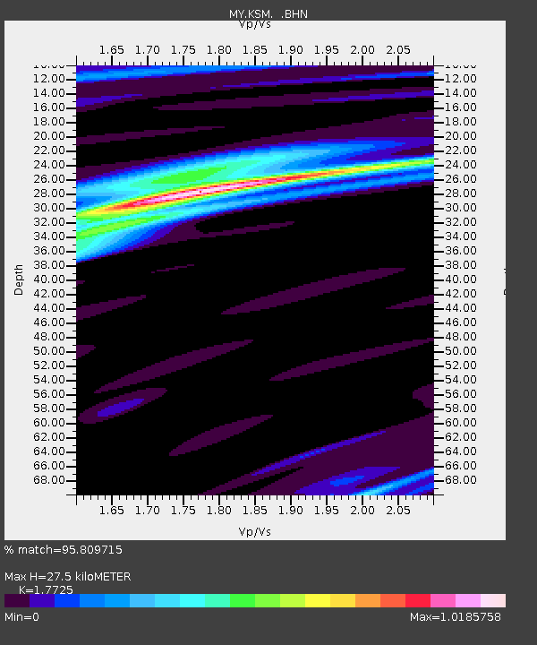
KSM Kuching - Earthquake Result Viewer

Earthquake location: Kuril Islands
Earthquake latitude/longitude: 46.3/153.3
Earthquake time(UTC): 2006/10/13 (286) 13:47:39 GMT
Earthquake Depth: 8.0 km
Earthquake Magnitude: 5.5 MB, 5.8 MS, 6.3 MW, 5.8 MW
Earthquake Catalog/Contributor: WHDF/NEIC
Network: MY Malaysian National Seismic Network
Station: KSM Kuching
Lat/Lon: 1.47 N/110.31 E
Elevation: 66 m
Distance: 58.3 deg
Az: 233.242 deg
Baz: 33.788 deg
Ray Param: 0.06296039
Estimated Moho Depth: 27.5 km
Estimated Crust Vp/Vs: 1.77
Assumed Crust Vp: 6.468 km/s
Estimated Crust Vs: 3.649 km/s
Estimated Crust Poisson's Ratio: 0.27
Radial Match: 95.809715 %
Radial Bump: 309
Transverse Match: 80.23758 %
Transverse Bump: 400
SOD ConfigId: 2665
Insert Time: 2010-03-09 03:38:46.790 +0000
GWidth: 2.5
Max Bumps: 400
Tol: 0.001

Signal To Noise

ChannelStoNSTALTA
MY:KSM: :BHN:20061013T13:57:03.770005Z4.23349482.5402747E-76.0004204E-8
MY:KSM: :BHE:20061013T13:57:03.770005Z2.3137551.4696259E-76.351692E-8
MY:KSM: :BHZ:20061013T13:57:03.770005Z7.8967637.8193733E-79.9019985E-8
Arrivals
Ps3.5 SECOND
PpPs11 SECOND
PsPs/PpSs15 SECOND