You are here: Home > Network List > TX - Texas Seismological Network Stations List
> Station WTFS Witchita Falls > Earthquake Result Viewer
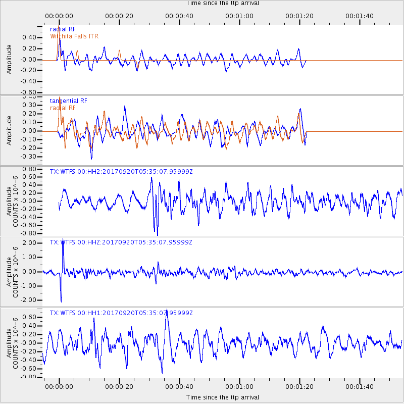
WTFS Witchita Falls - Earthquake Result Viewer
*The percent match for this event was below the threshold and hence no stack was calculated.
| Earthquake location: |
Southern Peru |
| Earthquake latitude/longitude: |
-16.3/-71.3 |
| Earthquake time(UTC): |
2017/09/20 (263) 05:26:08 GMT |
| Earthquake Depth: |
93 km |
| Earthquake Magnitude: |
5.3 Mww |
| Earthquake Catalog/Contributor: |
NEIC PDE/us |
|
| Network: |
TX Texas Seismological Network |
| Station: |
WTFS Witchita Falls |
| Lat/Lon: |
33.77 N/98.46 W |
| Elevation: |
277 m |
|
| Distance: |
56.1 deg |
| Az: |
332.742 deg |
| Baz: |
148.127 deg |
| Ray Param: |
$rayparam |
*The percent match for this event was below the threshold and hence was not used in the summary stack. |
|
| Radial Match: |
46.667946 % |
| Radial Bump: |
308 |
| Transverse Match: |
39.59844 % |
| Transverse Bump: |
281 |
| SOD ConfigId: |
2341311 |
| Insert Time: |
2017-10-04 13:09:35.554 +0000 |
| GWidth: |
2.5 |
| Max Bumps: |
400 |
| Tol: |
0.001 |
|
Signal To Noise
| Channel | StoN | STA | LTA |
| TX:WTFS:00:HHZ:20170920T05:35:07.95999Z | 9.110333 | 7.472358E-7 | 8.2020684E-8 |
| TX:WTFS:00:HH1:20170920T05:35:07.95999Z | 0.8737495 | 1.757353E-7 | 2.0112779E-7 |
| TX:WTFS:00:HH2:20170920T05:35:07.95999Z | 2.8164067 | 3.6675846E-7 | 1.3022212E-7 |
| Arrivals |
| Ps | |
| PpPs | |
| PsPs/PpSs | |


