You are here: Home > Network List > MY - Malaysian National Seismic Network Stations List
> Station KSM Kuching > Earthquake Result Viewer
KSM Kuching - Earthquake Result Viewer
| Earthquake location: |
Kermadec Islands Region |
| Earthquake latitude/longitude: |
-31.8/-179.3 |
| Earthquake time(UTC): |
2006/05/16 (136) 10:39:23 GMT |
| Earthquake Depth: |
152 km |
| Earthquake Magnitude: |
6.8 MB, 7.4 MW, 7.4 MW |
| Earthquake Catalog/Contributor: |
WHDF/NEIC |
|
| Network: |
MY Malaysian National Seismic Network |
| Station: |
KSM Kuching |
| Lat/Lon: |
1.47 N/110.31 E |
| Elevation: |
66 m |
|
| Distance: |
74.2 deg |
| Az: |
281.856 deg |
| Baz: |
123.512 deg |
| Ray Param: |
0.052113444 |
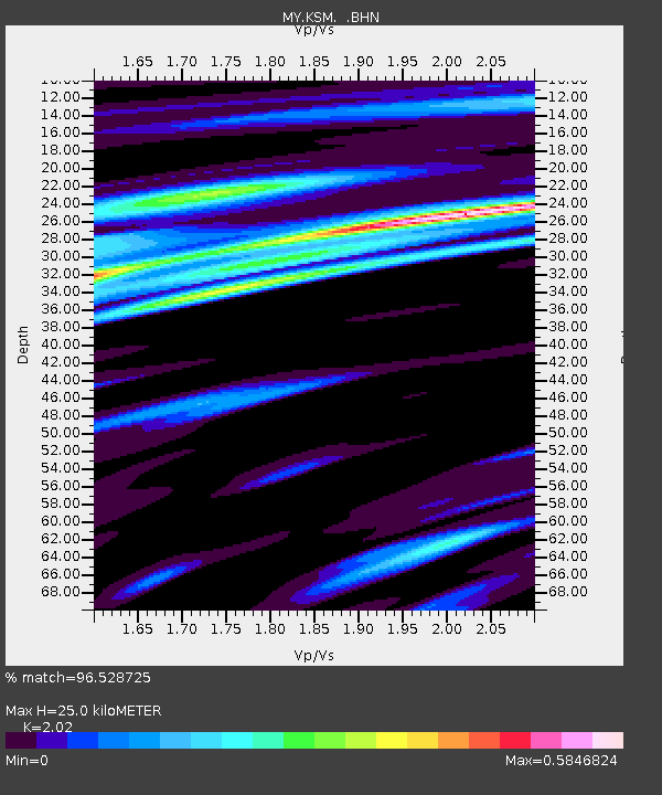
| Estimated Moho Depth: |
25.0 km |
| Estimated Crust Vp/Vs: |
2.02 |
| Assumed Crust Vp: |
6.468 km/s |
| Estimated Crust Vs: |
3.202 km/s |
| Estimated Crust Poisson's Ratio: |
0.34 |
|
| Radial Match: |
96.528725 % |
| Radial Bump: |
400 |
| Transverse Match: |
91.39655 % |
| Transverse Bump: |
400 |
| SOD ConfigId: |
2669 |
| Insert Time: |
2010-03-09 03:39:02.989 +0000 |
| GWidth: |
2.5 |
| Max Bumps: |
400 |
| Tol: |
0.001 |
|

Signal To Noise
| Channel | StoN | STA | LTA |
| MY:KSM: :BHN:20060516T10:50:12.420017Z | 7.412579 | 9.3844034E-7 | 1.2660105E-7 |
| MY:KSM: :BHE:20060516T10:50:12.420017Z | 5.2739315 | 9.830399E-7 | 1.8639602E-7 |
| MY:KSM: :BHZ:20060516T10:50:12.420017Z | 10.688616 | 3.8251524E-6 | 3.578716E-7 |
| Arrivals |
| Ps | 4.1 SECOND |
| PpPs | 11 SECOND |
| PsPs/PpSs | 15 SECOND |


