You are here: Home > Network List > US - United States National Seismic Network Stations List
> Station MSO Missoula, Montana, USA > Earthquake Result Viewer
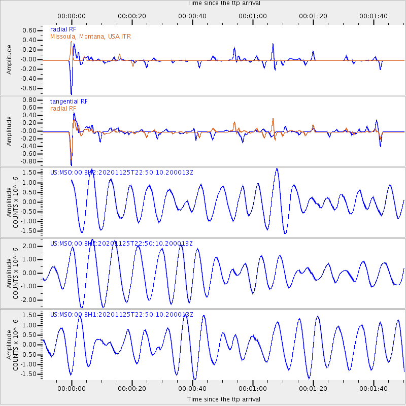
MSO Missoula, Montana, USA - Earthquake Result Viewer
*The percent match for this event was below the threshold and hence no stack was calculated.
| Earthquake location: |
Southeast Of Easter Island |
| Earthquake latitude/longitude: |
-41.1/-90.6 |
| Earthquake time(UTC): |
2020/11/25 (330) 22:37:42 GMT |
| Earthquake Depth: |
10 km |
| Earthquake Magnitude: |
5.7 Mww |
| Earthquake Catalog/Contributor: |
NEIC PDE/us |
|
| Network: |
US United States National Seismic Network |
| Station: |
MSO Missoula, Montana, USA |
| Lat/Lon: |
46.83 N/113.94 W |
| Elevation: |
1264 m |
|
| Distance: |
89.9 deg |
| Az: |
344.229 deg |
| Baz: |
162.58 deg |
| Ray Param: |
$rayparam |
*The percent match for this event was below the threshold and hence was not used in the summary stack. |
|
| Radial Match: |
78.02885 % |
| Radial Bump: |
400 |
| Transverse Match: |
59.136276 % |
| Transverse Bump: |
400 |
| SOD ConfigId: |
23341671 |
| Insert Time: |
2020-12-09 23:51:47.859 +0000 |
| GWidth: |
2.5 |
| Max Bumps: |
400 |
| Tol: |
0.001 |
|
Signal To Noise
| Channel | StoN | STA | LTA |
| US:MSO:00:BHZ:20201125T22:50:10.200013Z | 2.335745 | 1.6657428E-6 | 7.131527E-7 |
| US:MSO:00:BH1:20201125T22:50:10.200013Z | 1.7682941 | 1.0486092E-6 | 5.9300606E-7 |
| US:MSO:00:BH2:20201125T22:50:10.200013Z | 0.6155699 | 5.480397E-7 | 8.902965E-7 |
| Arrivals |
| Ps | |
| PpPs | |
| PsPs/PpSs | |


