You are here: Home > Network List > MY - Malaysian National Seismic Network Stations List
> Station KSM Kuching > Earthquake Result Viewer
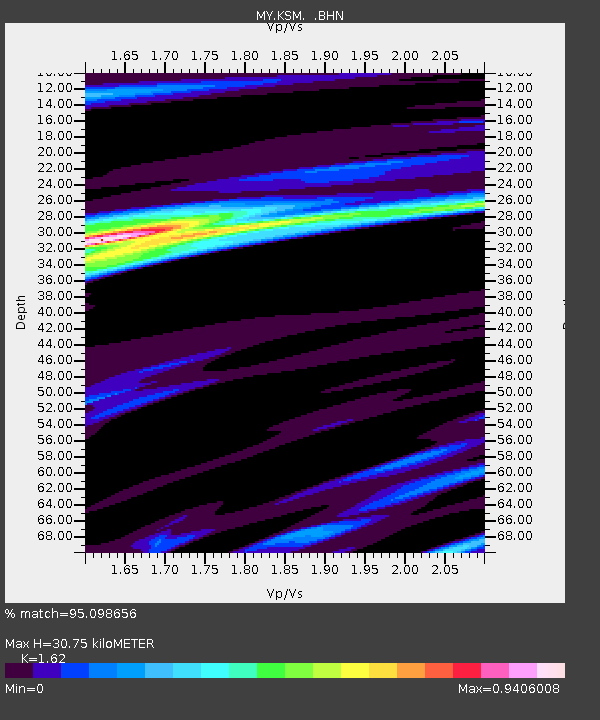
KSM Kuching - Earthquake Result Viewer
| Earthquake location: |
Southern Greece |
| Earthquake latitude/longitude: |
36.3/23.2 |
| Earthquake time(UTC): |
2006/01/08 (008) 11:34:55 GMT |
| Earthquake Depth: |
66 km |
| Earthquake Magnitude: |
6.5 MB, 6.7 MW, 6.7 MW |
| Earthquake Catalog/Contributor: |
WHDF/NEIC |
|
| Network: |
MY Malaysian National Seismic Network |
| Station: |
KSM Kuching |
| Lat/Lon: |
1.47 N/110.31 E |
| Elevation: |
66 m |
|
| Distance: |
86.8 deg |
| Az: |
90.53 deg |
| Baz: |
306.105 deg |
| Ray Param: |
0.043668892 |
| Estimated Moho Depth: |
30.75 km |
| Estimated Crust Vp/Vs: |
1.62 |
| Assumed Crust Vp: |
6.468 km/s |
| Estimated Crust Vs: |
3.992 km/s |
| Estimated Crust Poisson's Ratio: |
0.19 |
|
| Radial Match: |
95.098656 % |
| Radial Bump: |
400 |
| Transverse Match: |
91.87955 % |
| Transverse Bump: |
400 |
| SOD ConfigId: |
4977 |
| Insert Time: |
2010-03-09 03:39:35.548 +0000 |
| GWidth: |
2.5 |
| Max Bumps: |
400 |
| Tol: |
0.001 |
|

Signal To Noise
| Channel | StoN | STA | LTA |
| MY:KSM: :BHN:20060108T11:47:01.520005Z | 3.6782432 | 4.9554876E-7 | 1.347243E-7 |
| MY:KSM: :BHE:20060108T11:47:01.520005Z | 5.907426 | 9.616842E-7 | 1.6279243E-7 |
| MY:KSM: :BHZ:20060108T11:47:01.520005Z | 18.992186 | 3.4793902E-6 | 1.8320114E-7 |
| Arrivals |
| Ps | 3.0 SECOND |
| PpPs | 12 SECOND |
| PsPs/PpSs | 15 SECOND |


