You are here: Home > Network List > CN - Canadian National Seismograph Network Stations List
> Station MOBC Moresby, BC, CA > Earthquake Result Viewer
MOBC Moresby, BC, CA - Earthquake Result Viewer
| Earthquake location: |
Vanuatu Islands |
| Earthquake latitude/longitude: |
-14.8/167.3 |
| Earthquake time(UTC): |
2020/11/29 (334) 09:01:35 GMT |
| Earthquake Depth: |
112 km |
| Earthquake Magnitude: |
5.5 mww |
| Earthquake Catalog/Contributor: |
NEIC PDE/us |
|
| Network: |
CN Canadian National Seismograph Network |
| Station: |
MOBC Moresby, BC, CA |
| Lat/Lon: |
53.14 N/131.97 W |
| Elevation: |
675 m |
|
| Distance: |
85.3 deg |
| Az: |
31.834 deg |
| Baz: |
237.87 deg |
| Ray Param: |
0.044607975 |
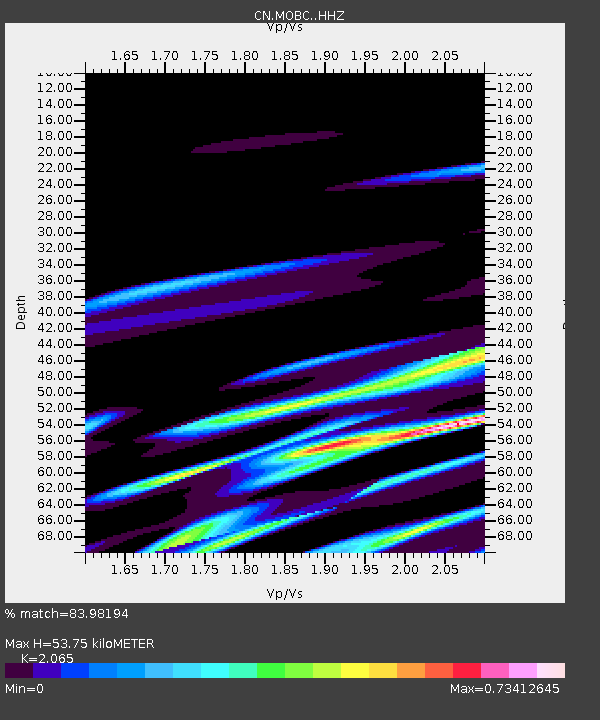
| Estimated Moho Depth: |
53.75 km |
| Estimated Crust Vp/Vs: |
2.07 |
| Assumed Crust Vp: |
6.134 km/s |
| Estimated Crust Vs: |
2.97 km/s |
| Estimated Crust Poisson's Ratio: |
0.35 |
|
| Radial Match: |
83.98194 % |
| Radial Bump: |
400 |
| Transverse Match: |
74.48029 % |
| Transverse Bump: |
400 |
| SOD ConfigId: |
23341671 |
| Insert Time: |
2020-12-13 10:08:01.399 +0000 |
| GWidth: |
2.5 |
| Max Bumps: |
400 |
| Tol: |
0.001 |
|

Signal To Noise
| Channel | StoN | STA | LTA |
| CN:MOBC: :HHZ:20201129T09:13:28.800028Z | 3.066596 | 6.4090905E-6 | 2.089969E-6 |
| CN:MOBC: :HHN:20201129T09:13:28.800028Z | 1.0321188 | 3.476814E-6 | 3.3686183E-6 |
| CN:MOBC: :HHE:20201129T09:13:28.800028Z | 1.5719818 | 6.875386E-6 | 4.373706E-6 |
| Arrivals |
| Ps | 9.5 SECOND |
| PpPs | 26 SECOND |
| PsPs/PpSs | 36 SECOND |


