You are here: Home > Network List > IW - Intermountain West Stations List
> Station MOOW Moose Ponds, Wyoming, USA > Earthquake Result Viewer
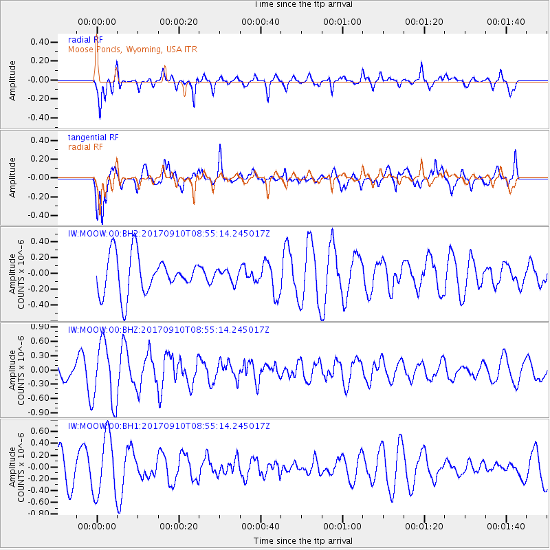
MOOW Moose Ponds, Wyoming, USA - Earthquake Result Viewer
*The percent match for this event was below the threshold and hence no stack was calculated.
| Earthquake location: |
Hokkaido, Japan Region |
| Earthquake latitude/longitude: |
41.8/142.9 |
| Earthquake time(UTC): |
2017/09/10 (253) 08:44:24 GMT |
| Earthquake Depth: |
45 km |
| Earthquake Magnitude: |
5.5 Mww |
| Earthquake Catalog/Contributor: |
NEIC PDE/us |
|
| Network: |
IW Intermountain West |
| Station: |
MOOW Moose Ponds, Wyoming, USA |
| Lat/Lon: |
43.75 N/110.74 W |
| Elevation: |
2128 m |
|
| Distance: |
72.3 deg |
| Az: |
46.892 deg |
| Baz: |
311.11 deg |
| Ray Param: |
$rayparam |
*The percent match for this event was below the threshold and hence was not used in the summary stack. |
|
| Radial Match: |
62.871437 % |
| Radial Bump: |
400 |
| Transverse Match: |
76.37403 % |
| Transverse Bump: |
400 |
| SOD ConfigId: |
2341311 |
| Insert Time: |
2017-10-04 13:44:42.827 +0000 |
| GWidth: |
2.5 |
| Max Bumps: |
400 |
| Tol: |
0.001 |
|
Signal To Noise
| Channel | StoN | STA | LTA |
| IW:MOOW:00:BHZ:20170910T08:55:14.245017Z | 3.665195 | 6.407075E-7 | 1.7480858E-7 |
| IW:MOOW:00:BH1:20170910T08:55:14.245017Z | 2.811105 | 5.1731183E-7 | 1.8402437E-7 |
| IW:MOOW:00:BH2:20170910T08:55:14.245017Z | 0.32638136 | 7.948198E-8 | 2.4352488E-7 |
| Arrivals |
| Ps | |
| PpPs | |
| PsPs/PpSs | |


