You are here: Home > Network List > XC91 - Tibetan Plateau Broadband Experiment Stations List
> Station AMDO XC.AMDO > Earthquake Result Viewer
AMDO XC.AMDO - Earthquake Result Viewer
| Earthquake location: |
Kuril Islands |
| Earthquake latitude/longitude: |
45.6/151.6 |
| Earthquake time(UTC): |
1991/12/13 (347) 02:33:52 GMT |
| Earthquake Depth: |
32 km |
| Earthquake Magnitude: |
6.2 MB, 6.5 MS |
| Earthquake Catalog/Contributor: |
WHDF/NEIC |
|
| Network: |
XC Tibetan Plateau Broadband Experiment |
| Station: |
AMDO XC.AMDO |
| Lat/Lon: |
32.25 N/91.69 E |
| Elevation: |
4712 m |
|
| Distance: |
47.5 deg |
| Az: |
275.511 deg |
| Baz: |
55.584 deg |
| Ray Param: |
0.06991228 |
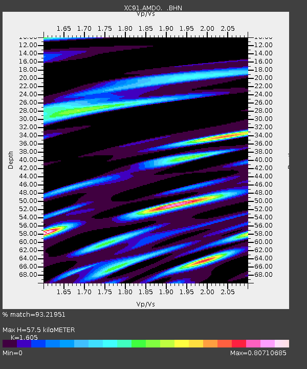
| Estimated Moho Depth: |
57.5 km |
| Estimated Crust Vp/Vs: |
1.61 |
| Assumed Crust Vp: |
6.5 km/s |
| Estimated Crust Vs: |
4.05 km/s |
| Estimated Crust Poisson's Ratio: |
0.18 |
|
| Radial Match: |
93.21951 % |
| Radial Bump: |
400 |
| Transverse Match: |
89.958015 % |
| Transverse Bump: |
383 |
| SOD ConfigId: |
23496 |
| Insert Time: |
2010-02-26 15:12:09.599 +0000 |
| GWidth: |
2.5 |
| Max Bumps: |
400 |
| Tol: |
0.001 |
|

Signal To Noise
| Channel | StoN | STA | LTA |
| XC:AMDO: :BHN:19911213T02:41:53.322009Z | 5.2135253 | 3.6955498E-7 | 7.088389E-8 |
| XC:AMDO: :BHE:19911213T02:41:53.322009Z | 12.355837 | 7.1780323E-7 | 5.8094265E-8 |
| XC:AMDO: :BHZ:19911213T02:41:53.322009Z | 31.055597 | 2.0473922E-6 | 6.592667E-8 |
| Arrivals |
| Ps | 5.7 SECOND |
| PpPs | 21 SECOND |
| PsPs/PpSs | 27 SECOND |


