You are here: Home > Network List > US - United States National Seismic Network Stations List
> Station WUAZ Wupatki, Arizona, USA > Earthquake Result Viewer
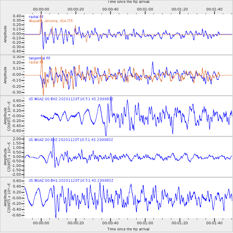
WUAZ Wupatki, Arizona, USA - Earthquake Result Viewer
*The percent match for this event was below the threshold and hence no stack was calculated.
| Earthquake location: |
Jujuy Province, Argentina |
| Earthquake latitude/longitude: |
-23.3/-65.0 |
| Earthquake time(UTC): |
2020/11/29 (334) 16:40:44 GMT |
| Earthquake Depth: |
10 km |
| Earthquake Magnitude: |
5.8 mww |
| Earthquake Catalog/Contributor: |
NEIC PDE/us |
|
| Network: |
US United States National Seismic Network |
| Station: |
WUAZ Wupatki, Arizona, USA |
| Lat/Lon: |
35.52 N/111.37 W |
| Elevation: |
1592 m |
|
| Distance: |
73.1 deg |
| Az: |
321.903 deg |
| Baz: |
135.925 deg |
| Ray Param: |
$rayparam |
*The percent match for this event was below the threshold and hence was not used in the summary stack. |
|
| Radial Match: |
66.56829 % |
| Radial Bump: |
400 |
| Transverse Match: |
81.45871 % |
| Transverse Bump: |
400 |
| SOD ConfigId: |
23341671 |
| Insert Time: |
2020-12-13 17:59:42.192 +0000 |
| GWidth: |
2.5 |
| Max Bumps: |
400 |
| Tol: |
0.001 |
|
Signal To Noise
| Channel | StoN | STA | LTA |
| US:WUAZ:00:BHZ:20201129T16:51:43.299983Z | 1.6346819 | 3.159582E-7 | 1.9328421E-7 |
| US:WUAZ:00:BH1:20201129T16:51:43.299983Z | 0.7626027 | 1.6369901E-7 | 2.1465833E-7 |
| US:WUAZ:00:BH2:20201129T16:51:43.299983Z | 2.6745446 | 2.805511E-7 | 1.0489678E-7 |
| Arrivals |
| Ps | |
| PpPs | |
| PsPs/PpSs | |


