You are here: Home > Network List > AK - Alaska Regional Network Stations List
> Station M26K Nabesna, AK, USA > Earthquake Result Viewer
M26K Nabesna, AK, USA - Earthquake Result Viewer
| Earthquake location: |
Primor'ye, Russia |
| Earthquake latitude/longitude: |
48.3/140.8 |
| Earthquake time(UTC): |
2020/11/30 (335) 22:54:34 GMT |
| Earthquake Depth: |
587 km |
| Earthquake Magnitude: |
6.4 mww |
| Earthquake Catalog/Contributor: |
NEIC PDE/us |
|
| Network: |
AK Alaska Regional Network |
| Station: |
M26K Nabesna, AK, USA |
| Lat/Lon: |
62.40 N/143.00 W |
| Elevation: |
888 m |
|
| Distance: |
42.9 deg |
| Az: |
41.64 deg |
| Baz: |
287.558 deg |
| Ray Param: |
0.06991084 |
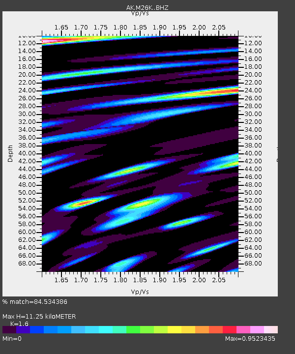
| Estimated Moho Depth: |
11.25 km |
| Estimated Crust Vp/Vs: |
1.60 |
| Assumed Crust Vp: |
6.566 km/s |
| Estimated Crust Vs: |
4.104 km/s |
| Estimated Crust Poisson's Ratio: |
0.18 |
|
| Radial Match: |
84.534386 % |
| Radial Bump: |
400 |
| Transverse Match: |
68.14302 % |
| Transverse Bump: |
400 |
| SOD ConfigId: |
23341671 |
| Insert Time: |
2020-12-14 23:57:50.944 +0000 |
| GWidth: |
2.5 |
| Max Bumps: |
400 |
| Tol: |
0.001 |
|

Signal To Noise
| Channel | StoN | STA | LTA |
| AK:M26K: :BHZ:20201130T23:01:11.940002Z | 31.389338 | 7.5343546E-6 | 2.400291E-7 |
| AK:M26K: :BHN:20201130T23:01:11.940002Z | 22.01915 | 3.9868146E-6 | 1.8106124E-7 |
| AK:M26K: :BHE:20201130T23:01:11.940002Z | 18.203827 | 4.0458945E-6 | 2.2225514E-7 |
| Arrivals |
| Ps | 1.1 SECOND |
| PpPs | 4.1 SECOND |
| PsPs/PpSs | 5.3 SECOND |


