You are here: Home > Network List > XC91 - Tibetan Plateau Broadband Experiment Stations List
> Station BUDO XC.BUDO > Earthquake Result Viewer
BUDO XC.BUDO - Earthquake Result Viewer

| Earthquake location: |
Kuril Islands |
| Earthquake latitude/longitude: |
45.5/151.5 |
| Earthquake time(UTC): |
1991/12/07 (341) 11:59:01 GMT |
| Earthquake Depth: |
52 km |
| Earthquake Magnitude: |
5.5 MB |
| Earthquake Catalog/Contributor: |
WHDF/NEIC |
|
| Network: |
XC Tibetan Plateau Broadband Experiment |
| Station: |
BUDO XC.BUDO |
| Lat/Lon: |
35.53 N/93.91 E |
| Elevation: |
4660 m |
|
| Distance: |
44.1 deg |
| Az: |
277.964 deg |
| Baz: |
58.673 deg |
| Ray Param: |
0.072015926 |
| Estimated Moho Depth: |
38.25 km |
| Estimated Crust Vp/Vs: |
1.82 |
| Assumed Crust Vp: |
6.481 km/s |
| Estimated Crust Vs: |
3.561 km/s |
| Estimated Crust Poisson's Ratio: |
0.28 |
|
| Radial Match: |
95.04688 % |
| Radial Bump: |
400 |
| Transverse Match: |
86.382866 % |
| Transverse Bump: |
400 |
| SOD ConfigId: |
23496 |
| Insert Time: |
2010-02-26 15:12:13.149 +0000 |
| GWidth: |
2.5 |
| Max Bumps: |
400 |
| Tol: |
0.001 |
|
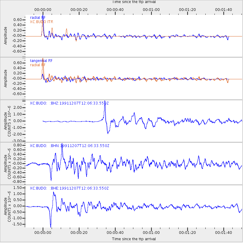
Signal To Noise
| Channel | StoN | STA | LTA |
| XC:BUDO: :BHN:19911207T12:06:33.550Z | 5.492479 | 2.1382863E-7 | 3.893117E-8 |
| XC:BUDO: :BHE:19911207T12:06:33.550Z | 14.910939 | 5.1350565E-7 | 3.4438184E-8 |
| XC:BUDO: :BHZ:19911207T12:06:33.550Z | 23.610779 | 9.047326E-7 | 3.8318625E-8 |
| Arrivals |
| Ps | 5.2 SECOND |
| PpPs | 16 SECOND |
| PsPs/PpSs | 21 SECOND |


