You are here: Home > Network List > GS - US Geological Survey Networks Stations List
> Station DEC05 Decatur Surface Seismic Site, Decatur, IL, USA > Earthquake Result Viewer
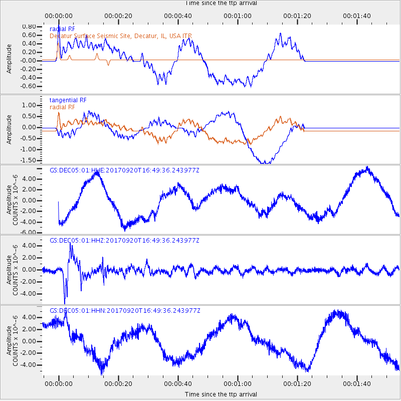
DEC05 Decatur Surface Seismic Site, Decatur, IL, USA - Earthquake Result Viewer
*The percent match for this event was below the threshold and hence no stack was calculated.
| Earthquake location: |
Off East Coast Of Honshu, Japan |
| Earthquake latitude/longitude: |
38.0/144.7 |
| Earthquake time(UTC): |
2017/09/20 (263) 16:37:16 GMT |
| Earthquake Depth: |
10 km |
| Earthquake Magnitude: |
6.1 Mww |
| Earthquake Catalog/Contributor: |
NEIC PDE/us |
|
| Network: |
GS US Geological Survey Networks |
| Station: |
DEC05 Decatur Surface Seismic Site, Decatur, IL, USA |
| Lat/Lon: |
39.87 N/88.87 W |
| Elevation: |
216 m |
|
| Distance: |
88.3 deg |
| Az: |
38.259 deg |
| Baz: |
320.521 deg |
| Ray Param: |
$rayparam |
*The percent match for this event was below the threshold and hence was not used in the summary stack. |
|
| Radial Match: |
7.4383125 % |
| Radial Bump: |
400 |
| Transverse Match: |
61.81565 % |
| Transverse Bump: |
400 |
| SOD ConfigId: |
2341311 |
| Insert Time: |
2017-10-04 18:04:27.519 +0000 |
| GWidth: |
2.5 |
| Max Bumps: |
400 |
| Tol: |
0.001 |
|
Signal To Noise
| Channel | StoN | STA | LTA |
| GS:DEC05:01:HHZ:20170920T16:49:36.243977Z | 7.8078113 | 2.40726E-6 | 3.083143E-7 |
| GS:DEC05:01:HHN:20170920T16:49:36.243977Z | 1.3745815 | 3.7915672E-6 | 2.758343E-6 |
| GS:DEC05:01:HHE:20170920T16:49:36.243977Z | 0.704356 | 2.3376826E-6 | 3.3188933E-6 |
| Arrivals |
| Ps | |
| PpPs | |
| PsPs/PpSs | |


