You are here: Home > Network List > MY - Malaysian National Seismic Network Stations List
> Station KUM Kulim > Earthquake Result Viewer
KUM Kulim - Earthquake Result Viewer
| Earthquake location: |
New Ireland Region, P.N.G. |
| Earthquake latitude/longitude: |
-4.5/153.5 |
| Earthquake time(UTC): |
2005/09/09 (252) 07:26:43 GMT |
| Earthquake Depth: |
90 km |
| Earthquake Magnitude: |
6.3 MB, 7.7 MW, 7.5 MW |
| Earthquake Catalog/Contributor: |
WHDF/NEIC |
|
| Network: |
MY Malaysian National Seismic Network |
| Station: |
KUM Kulim |
| Lat/Lon: |
5.29 N/100.65 E |
| Elevation: |
74 m |
|
| Distance: |
53.7 deg |
| Az: |
279.909 deg |
| Baz: |
99.537 deg |
| Ray Param: |
0.06567697 |
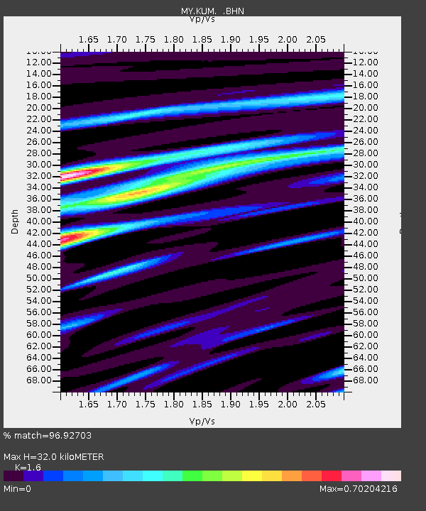
| Estimated Moho Depth: |
32.0 km |
| Estimated Crust Vp/Vs: |
1.60 |
| Assumed Crust Vp: |
6.468 km/s |
| Estimated Crust Vs: |
4.042 km/s |
| Estimated Crust Poisson's Ratio: |
0.18 |
|
| Radial Match: |
96.92703 % |
| Radial Bump: |
332 |
| Transverse Match: |
88.5556 % |
| Transverse Bump: |
400 |
| SOD ConfigId: |
2475 |
| Insert Time: |
2010-03-09 03:43:30.237 +0000 |
| GWidth: |
2.5 |
| Max Bumps: |
400 |
| Tol: |
0.001 |
|

Signal To Noise
| Channel | StoN | STA | LTA |
| MY:KUM: :BHN:20050909T07:35:25.469014Z | 6.402442 | 5.0125516E-7 | 7.8291244E-8 |
| MY:KUM: :BHE:20050909T07:35:25.469014Z | 25.476702 | 3.102677E-6 | 1.2178488E-7 |
| MY:KUM: :BHZ:20050909T07:35:25.469014Z | 33.76882 | 5.924375E-6 | 1.7543918E-7 |
| Arrivals |
| Ps | 3.2 SECOND |
| PpPs | 12 SECOND |
| PsPs/PpSs | 15 SECOND |


