You are here: Home > Network List > GS - US Geological Survey Networks Stations List
> Station MT02 Nevada Ogden Rd, Helena Natl Forest, Montana, USA > Earthquake Result Viewer
MT02 Nevada Ogden Rd, Helena Natl Forest, Montana, USA - Earthquake Result Viewer

| Earthquake location: |
Off East Coast Of Honshu, Japan |
| Earthquake latitude/longitude: |
38.0/144.7 |
| Earthquake time(UTC): |
2017/09/20 (263) 16:37:16 GMT |
| Earthquake Depth: |
10 km |
| Earthquake Magnitude: |
6.1 Mww |
| Earthquake Catalog/Contributor: |
NEIC PDE/us |
|
| Network: |
GS US Geological Survey Networks |
| Station: |
MT02 Nevada Ogden Rd, Helena Natl Forest, Montana, USA |
| Lat/Lon: |
46.86 N/112.88 W |
| Elevation: |
1672 m |
|
| Distance: |
70.8 deg |
| Az: |
45.2 deg |
| Baz: |
305.208 deg |
| Ray Param: |
0.05474235 |
| Estimated Moho Depth: |
11.0 km |
| Estimated Crust Vp/Vs: |
1.77 |
| Assumed Crust Vp: |
6.353 km/s |
| Estimated Crust Vs: |
3.594 km/s |
| Estimated Crust Poisson's Ratio: |
0.26 |
|
| Radial Match: |
89.768196 % |
| Radial Bump: |
372 |
| Transverse Match: |
68.91751 % |
| Transverse Bump: |
400 |
| SOD ConfigId: |
2341311 |
| Insert Time: |
2017-10-04 18:05:12.194 +0000 |
| GWidth: |
2.5 |
| Max Bumps: |
400 |
| Tol: |
0.001 |
|
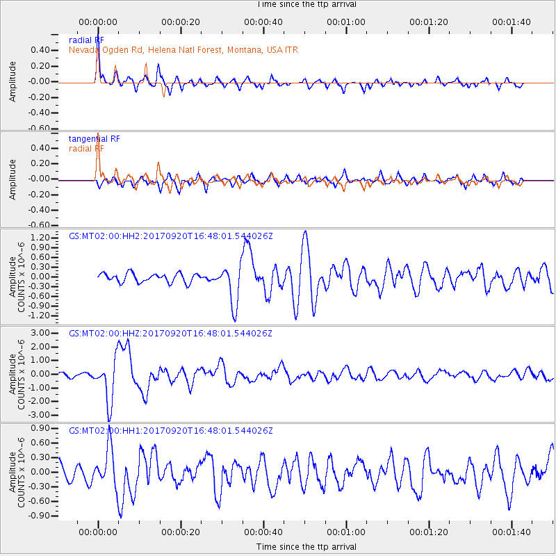
Signal To Noise
| Channel | StoN | STA | LTA |
| GS:MT02:00:HHZ:20170920T16:48:01.544026Z | 10.419344 | 1.6333206E-6 | 1.5675849E-7 |
| GS:MT02:00:HH1:20170920T16:48:01.544026Z | 3.479162 | 4.337914E-7 | 1.2468273E-7 |
| GS:MT02:00:HH2:20170920T16:48:01.544026Z | 4.667985 | 6.414788E-7 | 1.3742093E-7 |
| Arrivals |
| Ps | 1.4 SECOND |
| PpPs | 4.6 SECOND |
| PsPs/PpSs | 6.0 SECOND |


