You are here: Home > Network List > MY - Malaysian National Seismic Network Stations List
> Station KUM Kulim > Earthquake Result Viewer
KUM Kulim - Earthquake Result Viewer
| Earthquake location: |
Sea Of Japan |
| Earthquake latitude/longitude: |
36.8/134.9 |
| Earthquake time(UTC): |
2007/07/16 (197) 14:17:37 GMT |
| Earthquake Depth: |
350 km |
| Earthquake Magnitude: |
6.2 MB, 6.8 MW, 6.8 MW |
| Earthquake Catalog/Contributor: |
WHDF/NEIC |
|
| Network: |
MY Malaysian National Seismic Network |
| Station: |
KUM Kulim |
| Lat/Lon: |
5.29 N/100.65 E |
| Elevation: |
74 m |
|
| Distance: |
44.3 deg |
| Az: |
233.26 deg |
| Baz: |
40.231 deg |
| Ray Param: |
0.070515946 |
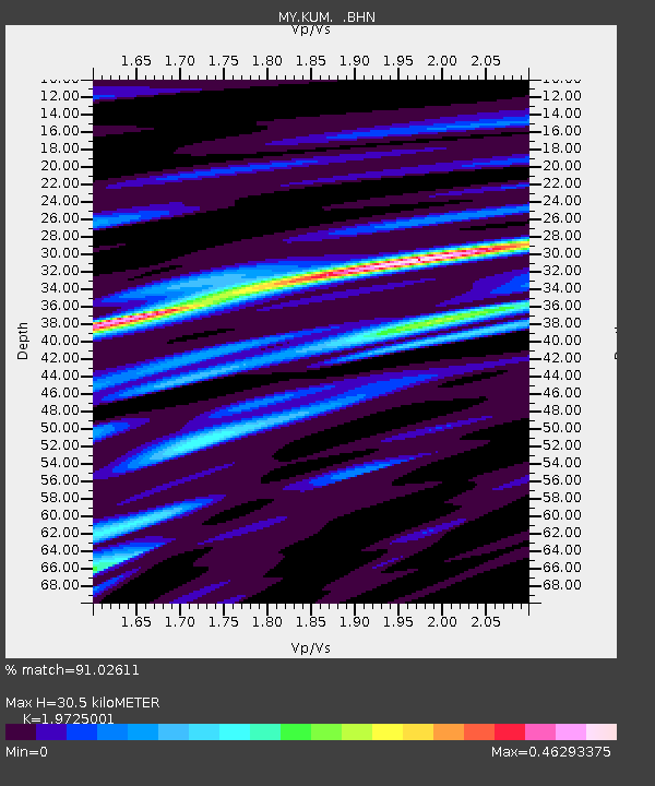
| Estimated Moho Depth: |
30.5 km |
| Estimated Crust Vp/Vs: |
1.97 |
| Assumed Crust Vp: |
6.468 km/s |
| Estimated Crust Vs: |
3.279 km/s |
| Estimated Crust Poisson's Ratio: |
0.33 |
|
| Radial Match: |
91.02611 % |
| Radial Bump: |
280 |
| Transverse Match: |
85.99888 % |
| Transverse Bump: |
400 |
| SOD ConfigId: |
2564 |
| Insert Time: |
2010-03-09 03:44:10.365 +0000 |
| GWidth: |
2.5 |
| Max Bumps: |
400 |
| Tol: |
0.001 |
|

Signal To Noise
| Channel | StoN | STA | LTA |
| MY:KUM: :BHN:20070716T14:24:43.220005Z | 60.131496 | 3.6566046E-6 | 6.081014E-8 |
| MY:KUM: :BHE:20070716T14:24:43.220005Z | 14.783483 | 1.4255604E-6 | 9.642927E-8 |
| MY:KUM: :BHZ:20070716T14:24:43.220005Z | 60.343166 | 7.0487804E-6 | 1.1681158E-7 |
| Arrivals |
| Ps | 4.9 SECOND |
| PpPs | 13 SECOND |
| PsPs/PpSs | 18 SECOND |


