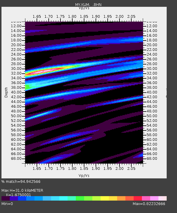
KUM Kulim - Earthquake Result Viewer

Earthquake location: New Ireland Region, P.N.G.
Earthquake latitude/longitude: -3.6/151.0
Earthquake time(UTC): 2007/06/18 (169) 06:18:48 GMT
Earthquake Depth: 26 km
Earthquake Magnitude: 5.7 MB, 6.2 MS, 6.3 MW, 6.1 MW
Earthquake Catalog/Contributor: WHDF/NEIC
Network: MY Malaysian National Seismic Network
Station: KUM Kulim
Lat/Lon: 5.29 N/100.65 E
Elevation: 74 m
Distance: 51.0 deg
Az: 279.681 deg
Baz: 98.874 deg
Ray Param: 0.067640506
Estimated Moho Depth: 31.0 km
Estimated Crust Vp/Vs: 1.68
Assumed Crust Vp: 6.468 km/s
Estimated Crust Vs: 3.861 km/s
Estimated Crust Poisson's Ratio: 0.22
Radial Match: 94.942566 %
Radial Bump: 351
Transverse Match: 90.46321 %
Transverse Bump: 400
SOD ConfigId: 2564
Insert Time: 2010-03-09 03:44:15.720 +0000
GWidth: 2.5
Max Bumps: 400
Tol: 0.001

Signal To Noise

ChannelStoNSTALTA
MY:KUM: :BHN:20070618T06:27:17.169009Z1.22670761.2191273E-79.938207E-8
MY:KUM: :BHE:20070618T06:27:17.169009Z4.9853814.4694968E-78.965206E-8
MY:KUM: :BHZ:20070618T06:27:17.169009Z8.0619448.4508736E-71.0482427E-7
Arrivals
Ps3.4 SECOND
PpPs12 SECOND
PsPs/PpSs15 SECOND