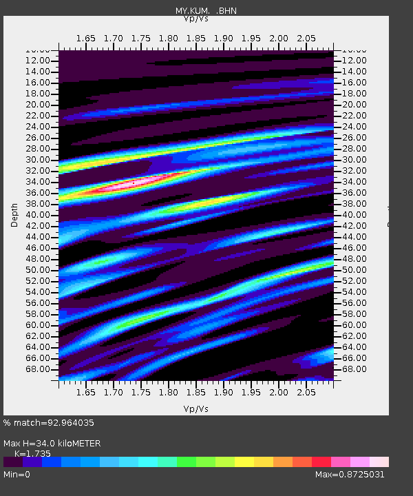
KUM Kulim - Earthquake Result Viewer

Earthquake location: Bismarck Sea
Earthquake latitude/longitude: -3.3/146.8
Earthquake time(UTC): 2007/06/07 (158) 00:40:38 GMT
Earthquake Depth: 4.7 km
Earthquake Magnitude: 5.8 MB, 6.2 MS, 6.2 MW, 6.2 MW
Earthquake Catalog/Contributor: WHDF/NEIC
Network: MY Malaysian National Seismic Network
Station: KUM Kulim
Lat/Lon: 5.29 N/100.65 E
Elevation: 74 m
Distance: 46.8 deg
Az: 280.353 deg
Baz: 99.516 deg
Ray Param: 0.07039714
Estimated Moho Depth: 34.0 km
Estimated Crust Vp/Vs: 1.74
Assumed Crust Vp: 6.468 km/s
Estimated Crust Vs: 3.728 km/s
Estimated Crust Poisson's Ratio: 0.25
Radial Match: 92.964035 %
Radial Bump: 400
Transverse Match: 80.16259 %
Transverse Bump: 400
SOD ConfigId: 2564
Insert Time: 2010-03-09 03:44:17.200 +0000
GWidth: 2.5
Max Bumps: 400
Tol: 0.001

Signal To Noise

ChannelStoNSTALTA
MY:KUM: :BHN:20070607T00:48:38.119014Z1.49461328.364068E-85.5961422E-8
MY:KUM: :BHE:20070607T00:48:38.119014Z3.81921942.3666924E-76.196796E-8
MY:KUM: :BHZ:20070607T00:48:38.119014Z6.554233.908125E-75.962752E-8
Arrivals
Ps4.1 SECOND
PpPs13 SECOND
PsPs/PpSs18 SECOND