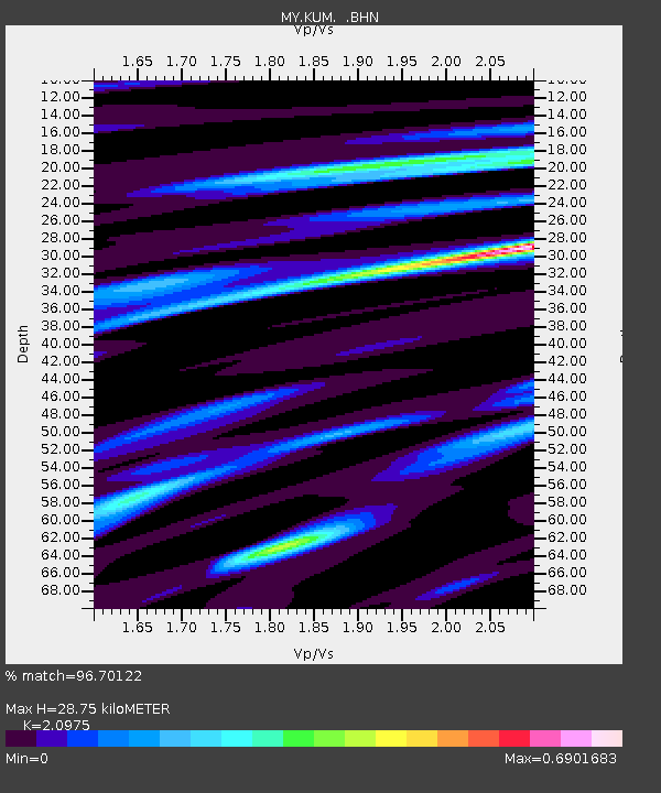
KUM Kulim - Earthquake Result Viewer

Earthquake location: Eastern Siberia, Russia
Earthquake latitude/longitude: 60.9/167.1
Earthquake time(UTC): 2006/04/20 (110) 23:25:02 GMT
Earthquake Depth: 22 km
Earthquake Magnitude: 6.8 MB, 7.6 MS, 7.6 MW, 7.3 MW
Earthquake Catalog/Contributor: WHDF/NEIC
Network: MY Malaysian National Seismic Network
Station: KUM Kulim
Lat/Lon: 5.29 N/100.65 E
Elevation: 74 m
Distance: 74.1 deg
Az: 251.653 deg
Baz: 27.725 deg
Ray Param: 0.05254695
Estimated Moho Depth: 28.75 km
Estimated Crust Vp/Vs: 2.10
Assumed Crust Vp: 6.468 km/s
Estimated Crust Vs: 3.084 km/s
Estimated Crust Poisson's Ratio: 0.35
Radial Match: 96.70122 %
Radial Bump: 362
Transverse Match: 94.157974 %
Transverse Bump: 400
SOD ConfigId: 2669
Insert Time: 2010-03-09 03:45:56.881 +0000
GWidth: 2.5
Max Bumps: 400
Tol: 0.001

Signal To Noise

ChannelStoNSTALTA
MY:KUM: :BHN:20060420T23:36:05.220007Z21.3648871.8954951E-68.872011E-8
MY:KUM: :BHE:20060420T23:36:05.220007Z5.03816374.916799E-79.7591084E-8
MY:KUM: :BHZ:20060420T23:36:05.220007Z51.183924.7037947E-69.189986E-8
Arrivals
Ps5.0 SECOND
PpPs13 SECOND
PsPs/PpSs18 SECOND