You are here: Home > Network List > TA - USArray Transportable Network (new EarthScope stations) Stations List
> Station D19K Kuna River, AK, USA > Earthquake Result Viewer
D19K Kuna River, AK, USA - Earthquake Result Viewer
| Earthquake location: |
Primor'ye, Russia |
| Earthquake latitude/longitude: |
48.3/140.8 |
| Earthquake time(UTC): |
2020/11/30 (335) 22:54:34 GMT |
| Earthquake Depth: |
587 km |
| Earthquake Magnitude: |
6.4 mww |
| Earthquake Catalog/Contributor: |
NEIC PDE/us |
|
| Network: |
TA USArray Transportable Network (new EarthScope stations) |
| Station: |
D19K Kuna River, AK, USA |
| Lat/Lon: |
68.49 N/158.12 W |
| Elevation: |
671 m |
|
| Distance: |
35.8 deg |
| Az: |
33.451 deg |
| Baz: |
267.441 deg |
| Ray Param: |
0.074026845 |
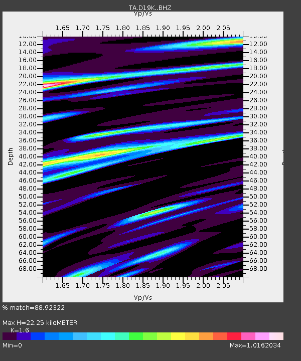
| Estimated Moho Depth: |
22.25 km |
| Estimated Crust Vp/Vs: |
1.60 |
| Assumed Crust Vp: |
6.221 km/s |
| Estimated Crust Vs: |
3.888 km/s |
| Estimated Crust Poisson's Ratio: |
0.18 |
|
| Radial Match: |
88.92322 % |
| Radial Bump: |
400 |
| Transverse Match: |
86.074554 % |
| Transverse Bump: |
400 |
| SOD ConfigId: |
23341671 |
| Insert Time: |
2020-12-15 00:25:48.779 +0000 |
| GWidth: |
2.5 |
| Max Bumps: |
400 |
| Tol: |
0.001 |
|

Signal To Noise
| Channel | StoN | STA | LTA |
| TA:D19K: :BHZ:20201130T23:00:15.524994Z | 95.42242 | 1.6996999E-5 | 1.7812374E-7 |
| TA:D19K: :BHN:20201130T23:00:15.524994Z | 22.863838 | 5.346559E-6 | 2.3384347E-7 |
| TA:D19K: :BHE:20201130T23:00:15.524994Z | 34.405815 | 7.1792488E-6 | 2.0866382E-7 |
| Arrivals |
| Ps | 2.3 SECOND |
| PpPs | 8.7 SECOND |
| PsPs/PpSs | 11 SECOND |


