You are here: Home > Network List > TA - USArray Transportable Network (new EarthScope stations) Stations List
> Station G21K Allakaket, AK, USA > Earthquake Result Viewer
G21K Allakaket, AK, USA - Earthquake Result Viewer
| Earthquake location: |
Primor'ye, Russia |
| Earthquake latitude/longitude: |
48.3/140.8 |
| Earthquake time(UTC): |
2020/11/30 (335) 22:54:34 GMT |
| Earthquake Depth: |
587 km |
| Earthquake Magnitude: |
6.4 mww |
| Earthquake Catalog/Contributor: |
NEIC PDE/us |
|
| Network: |
TA USArray Transportable Network (new EarthScope stations) |
| Station: |
G21K Allakaket, AK, USA |
| Lat/Lon: |
66.52 N/153.51 W |
| Elevation: |
446 m |
|
| Distance: |
37.6 deg |
| Az: |
36.726 deg |
| Baz: |
274.322 deg |
| Ray Param: |
0.07300838 |
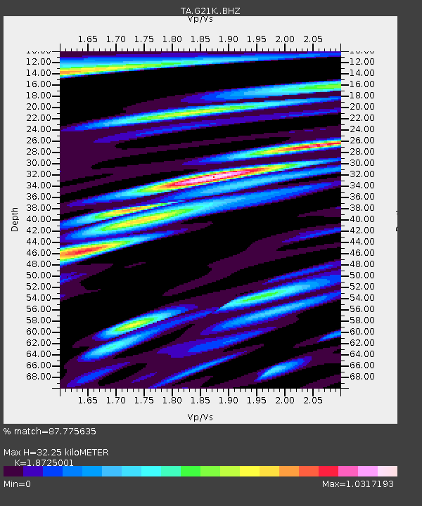
| Estimated Moho Depth: |
32.25 km |
| Estimated Crust Vp/Vs: |
1.87 |
| Assumed Crust Vp: |
6.455 km/s |
| Estimated Crust Vs: |
3.447 km/s |
| Estimated Crust Poisson's Ratio: |
0.30 |
|
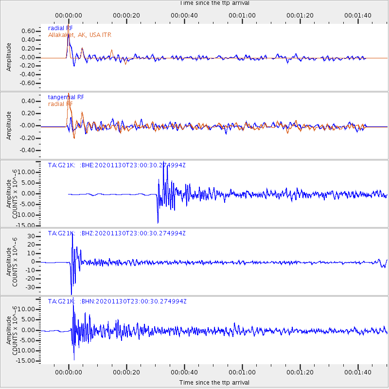
| Radial Match: |
87.775635 % |
| Radial Bump: |
400 |
| Transverse Match: |
69.40698 % |
| Transverse Bump: |
400 |
| SOD ConfigId: |
23341671 |
| Insert Time: |
2020-12-15 00:26:20.112 +0000 |
| GWidth: |
2.5 |
| Max Bumps: |
400 |
| Tol: |
0.001 |
|
Signal To Noise
| Channel | StoN | STA | LTA |
| TA:G21K: :BHZ:20201130T23:00:30.274994Z | 61.749504 | 1.3068138E-5 | 2.1163149E-7 |
| TA:G21K: :BHN:20201130T23:00:30.274994Z | 28.073652 | 4.554121E-6 | 1.6222046E-7 |
| TA:G21K: :BHE:20201130T23:00:30.274994Z | 28.66435 | 5.2021214E-6 | 1.8148401E-7 |
| Arrivals |
| Ps | 4.6 SECOND |
| PpPs | 13 SECOND |
| PsPs/PpSs | 18 SECOND |


