You are here: Home > Network List > TA - USArray Transportable Network (new EarthScope stations) Stations List
> Station I30M Mount Dempster, Yukon, CAN > Earthquake Result Viewer
I30M Mount Dempster, Yukon, CAN - Earthquake Result Viewer
| Earthquake location: |
Primor'ye, Russia |
| Earthquake latitude/longitude: |
48.3/140.8 |
| Earthquake time(UTC): |
2020/11/30 (335) 22:54:34 GMT |
| Earthquake Depth: |
587 km |
| Earthquake Magnitude: |
6.4 mww |
| Earthquake Catalog/Contributor: |
NEIC PDE/us |
|
| Network: |
TA USArray Transportable Network (new EarthScope stations) |
| Station: |
I30M Mount Dempster, Yukon, CAN |
| Lat/Lon: |
65.22 N/136.38 W |
| Elevation: |
1399 m |
|
| Distance: |
44.8 deg |
| Az: |
36.415 deg |
| Baz: |
289.722 deg |
| Ray Param: |
0.068789124 |
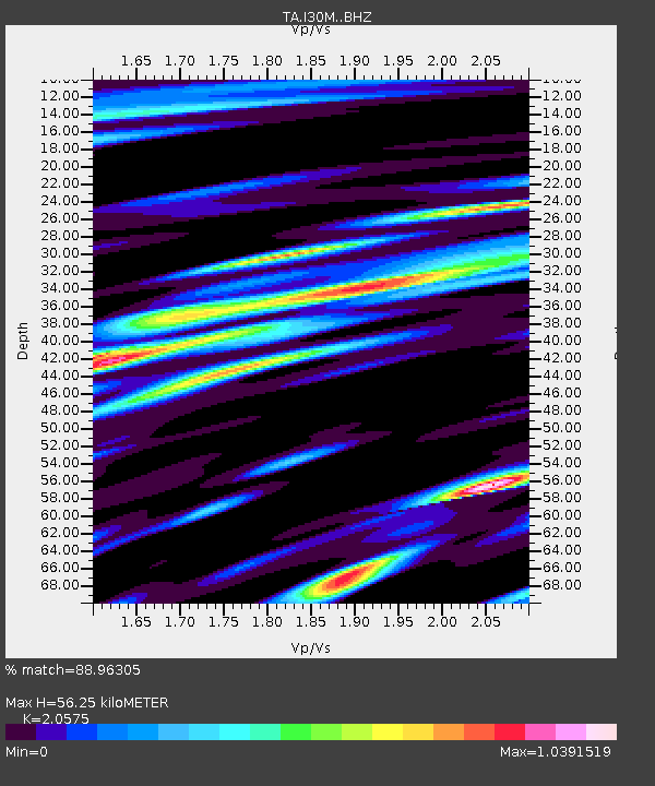
| Estimated Moho Depth: |
56.25 km |
| Estimated Crust Vp/Vs: |
2.06 |
| Assumed Crust Vp: |
6.566 km/s |
| Estimated Crust Vs: |
3.191 km/s |
| Estimated Crust Poisson's Ratio: |
0.35 |
|
| Radial Match: |
88.96305 % |
| Radial Bump: |
400 |
| Transverse Match: |
80.52411 % |
| Transverse Bump: |
400 |
| SOD ConfigId: |
23341671 |
| Insert Time: |
2020-12-15 00:26:42.285 +0000 |
| GWidth: |
2.5 |
| Max Bumps: |
400 |
| Tol: |
0.001 |
|
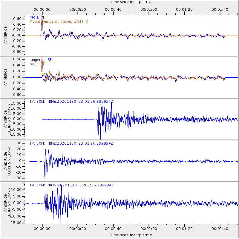
Signal To Noise
| Channel | StoN | STA | LTA |
| TA:I30M: :BHZ:20201130T23:01:26.399994Z | 64.3279 | 1.06819225E-5 | 1.6605426E-7 |
| TA:I30M: :BHN:20201130T23:01:26.399994Z | 17.00402 | 3.2478006E-6 | 1.9100192E-7 |
| TA:I30M: :BHE:20201130T23:01:26.399994Z | 48.550102 | 7.2432563E-6 | 1.4919137E-7 |
| Arrivals |
| Ps | 9.6 SECOND |
| PpPs | 25 SECOND |
| PsPs/PpSs | 34 SECOND |


