You are here: Home > Network List > TA - USArray Transportable Network (new EarthScope stations) Stations List
> Station J16K Anvik River, AK, USA > Earthquake Result Viewer
J16K Anvik River, AK, USA - Earthquake Result Viewer
| Earthquake location: |
Primor'ye, Russia |
| Earthquake latitude/longitude: |
48.3/140.8 |
| Earthquake time(UTC): |
2020/11/30 (335) 22:54:34 GMT |
| Earthquake Depth: |
587 km |
| Earthquake Magnitude: |
6.4 mww |
| Earthquake Catalog/Contributor: |
NEIC PDE/us |
|
| Network: |
TA USArray Transportable Network (new EarthScope stations) |
| Station: |
J16K Anvik River, AK, USA |
| Lat/Lon: |
63.28 N/160.60 W |
| Elevation: |
328 m |
|
| Distance: |
34.8 deg |
| Az: |
42.506 deg |
| Baz: |
272.565 deg |
| Ray Param: |
0.074575834 |
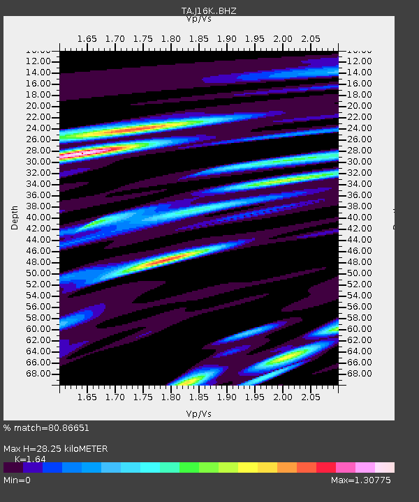
| Estimated Moho Depth: |
28.25 km |
| Estimated Crust Vp/Vs: |
1.64 |
| Assumed Crust Vp: |
6.276 km/s |
| Estimated Crust Vs: |
3.827 km/s |
| Estimated Crust Poisson's Ratio: |
0.20 |
|
| Radial Match: |
80.86651 % |
| Radial Bump: |
400 |
| Transverse Match: |
56.14544 % |
| Transverse Bump: |
400 |
| SOD ConfigId: |
23341671 |
| Insert Time: |
2020-12-15 00:26:45.412 +0000 |
| GWidth: |
2.5 |
| Max Bumps: |
400 |
| Tol: |
0.001 |
|

Signal To Noise
| Channel | StoN | STA | LTA |
| TA:J16K: :BHZ:20201130T23:00:07.075012Z | 7.9814057 | 3.2154867E-6 | 4.0287222E-7 |
| TA:J16K: :BHN:20201130T23:00:07.075012Z | 1.786272 | 5.5361124E-7 | 3.099255E-7 |
| TA:J16K: :BHE:20201130T23:00:07.075012Z | 7.6952863 | 1.7608135E-6 | 2.2881714E-7 |
| Arrivals |
| Ps | 3.1 SECOND |
| PpPs | 11 SECOND |
| PsPs/PpSs | 14 SECOND |


