You are here: Home > Network List > US - United States National Seismic Network Stations List
> Station CBKS Cedar Bluff, Kansas, USA > Earthquake Result Viewer
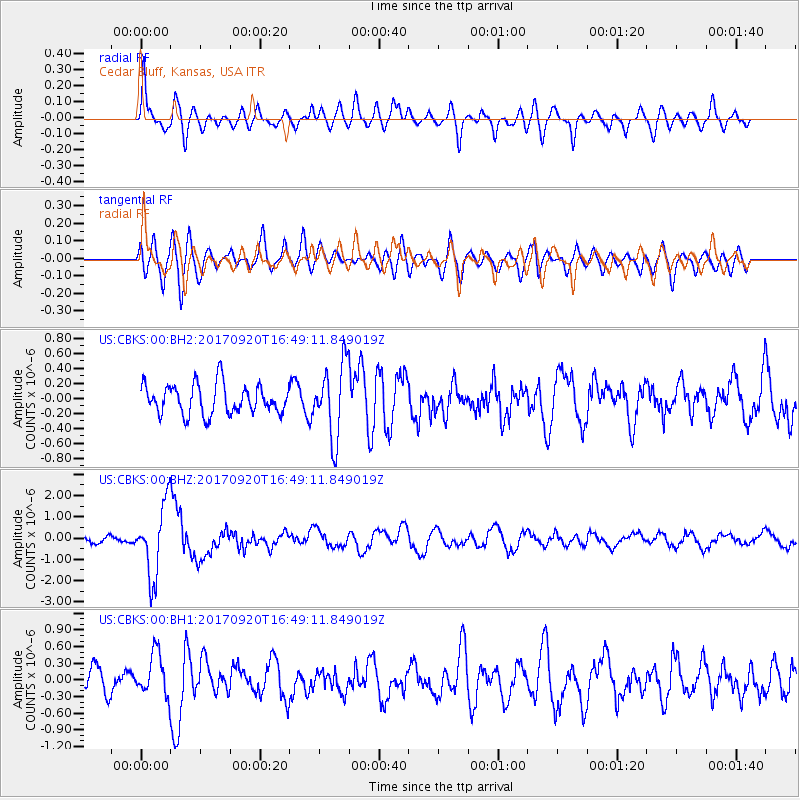
CBKS Cedar Bluff, Kansas, USA - Earthquake Result Viewer
*The percent match for this event was below the threshold and hence no stack was calculated.
| Earthquake location: |
Off East Coast Of Honshu, Japan |
| Earthquake latitude/longitude: |
38.0/144.7 |
| Earthquake time(UTC): |
2017/09/20 (263) 16:37:16 GMT |
| Earthquake Depth: |
10 km |
| Earthquake Magnitude: |
6.1 Mww |
| Earthquake Catalog/Contributor: |
NEIC PDE/us |
|
| Network: |
US United States National Seismic Network |
| Station: |
CBKS Cedar Bluff, Kansas, USA |
| Lat/Lon: |
38.81 N/99.74 W |
| Elevation: |
677 m |
|
| Distance: |
83.3 deg |
| Az: |
45.183 deg |
| Baz: |
314.151 deg |
| Ray Param: |
$rayparam |
*The percent match for this event was below the threshold and hence was not used in the summary stack. |
|
| Radial Match: |
72.22599 % |
| Radial Bump: |
400 |
| Transverse Match: |
69.059425 % |
| Transverse Bump: |
400 |
| SOD ConfigId: |
2341311 |
| Insert Time: |
2017-10-04 18:11:36.476 +0000 |
| GWidth: |
2.5 |
| Max Bumps: |
400 |
| Tol: |
0.001 |
|
Signal To Noise
| Channel | StoN | STA | LTA |
| US:CBKS:00:BHZ:20170920T16:49:11.849019Z | 9.484475 | 1.678432E-6 | 1.7696625E-7 |
| US:CBKS:00:BH1:20170920T16:49:11.849019Z | 1.9613241 | 3.8828117E-7 | 1.9796889E-7 |
| US:CBKS:00:BH2:20170920T16:49:11.849019Z | 2.4976285 | 4.9549425E-7 | 1.9838589E-7 |
| Arrivals |
| Ps | |
| PpPs | |
| PsPs/PpSs | |


