You are here: Home > Network List > US - United States National Seismic Network Stations List
> Station EGMT Eagleton, Montana, USA > Earthquake Result Viewer
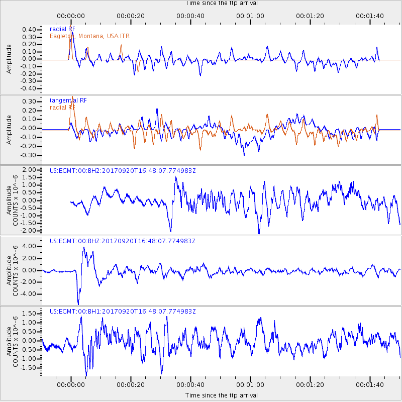
EGMT Eagleton, Montana, USA - Earthquake Result Viewer
*The percent match for this event was below the threshold and hence no stack was calculated.
| Earthquake location: |
Off East Coast Of Honshu, Japan |
| Earthquake latitude/longitude: |
38.0/144.7 |
| Earthquake time(UTC): |
2017/09/20 (263) 16:37:16 GMT |
| Earthquake Depth: |
10 km |
| Earthquake Magnitude: |
6.1 Mww |
| Earthquake Catalog/Contributor: |
NEIC PDE/us |
|
| Network: |
US United States National Seismic Network |
| Station: |
EGMT Eagleton, Montana, USA |
| Lat/Lon: |
48.02 N/109.75 W |
| Elevation: |
1055 m |
|
| Distance: |
71.8 deg |
| Az: |
42.888 deg |
| Baz: |
306.763 deg |
| Ray Param: |
$rayparam |
*The percent match for this event was below the threshold and hence was not used in the summary stack. |
|
| Radial Match: |
77.02944 % |
| Radial Bump: |
400 |
| Transverse Match: |
52.70472 % |
| Transverse Bump: |
400 |
| SOD ConfigId: |
2341311 |
| Insert Time: |
2017-10-04 18:11:48.639 +0000 |
| GWidth: |
2.5 |
| Max Bumps: |
400 |
| Tol: |
0.001 |
|
Signal To Noise
| Channel | StoN | STA | LTA |
| US:EGMT:00:BHZ:20170920T16:48:07.774983Z | 14.036798 | 2.4808214E-6 | 1.7673699E-7 |
| US:EGMT:00:BH1:20170920T16:48:07.774983Z | 1.8856863 | 6.223232E-7 | 3.300248E-7 |
| US:EGMT:00:BH2:20170920T16:48:07.774983Z | 2.3341784 | 8.6986387E-7 | 3.7266383E-7 |
| Arrivals |
| Ps | |
| PpPs | |
| PsPs/PpSs | |


