You are here: Home > Network List > US - United States National Seismic Network Stations List
> Station ERPA Erie, Pennsylvania, USA > Earthquake Result Viewer
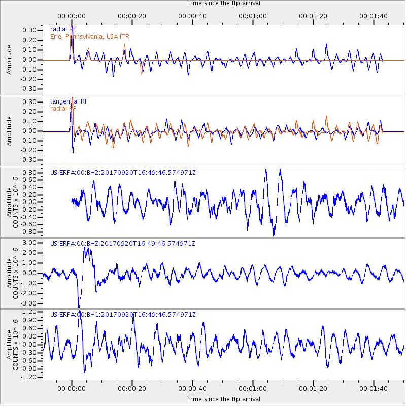
ERPA Erie, Pennsylvania, USA - Earthquake Result Viewer
*The percent match for this event was below the threshold and hence no stack was calculated.
| Earthquake location: |
Off East Coast Of Honshu, Japan |
| Earthquake latitude/longitude: |
38.0/144.7 |
| Earthquake time(UTC): |
2017/09/20 (263) 16:37:16 GMT |
| Earthquake Depth: |
10 km |
| Earthquake Magnitude: |
6.1 Mww |
| Earthquake Catalog/Contributor: |
NEIC PDE/us |
|
| Network: |
US United States National Seismic Network |
| Station: |
ERPA Erie, Pennsylvania, USA |
| Lat/Lon: |
42.12 N/79.99 W |
| Elevation: |
306 m |
|
| Distance: |
90.5 deg |
| Az: |
31.531 deg |
| Baz: |
326.259 deg |
| Ray Param: |
$rayparam |
*The percent match for this event was below the threshold and hence was not used in the summary stack. |
|
| Radial Match: |
63.226353 % |
| Radial Bump: |
400 |
| Transverse Match: |
63.75711 % |
| Transverse Bump: |
400 |
| SOD ConfigId: |
2341311 |
| Insert Time: |
2017-10-04 18:11:52.057 +0000 |
| GWidth: |
2.5 |
| Max Bumps: |
400 |
| Tol: |
0.001 |
|
Signal To Noise
| Channel | StoN | STA | LTA |
| US:ERPA:00:BHZ:20170920T16:49:46.574971Z | 4.2899356 | 1.5589372E-6 | 3.633941E-7 |
| US:ERPA:00:BH1:20170920T16:49:46.574971Z | 1.7771077 | 6.292668E-7 | 3.5409604E-7 |
| US:ERPA:00:BH2:20170920T16:49:46.574971Z | 1.1399963 | 2.9232766E-7 | 2.564286E-7 |
| Arrivals |
| Ps | |
| PpPs | |
| PsPs/PpSs | |


