You are here: Home > Network List > UU - University of Utah Regional Network Stations List
> Station MTPU Mt. Pierson, UT, USA > Earthquake Result Viewer
MTPU Mt. Pierson, UT, USA - Earthquake Result Viewer
| Earthquake location: |
Off East Coast Of Honshu, Japan |
| Earthquake latitude/longitude: |
38.0/144.7 |
| Earthquake time(UTC): |
2017/09/20 (263) 16:37:16 GMT |
| Earthquake Depth: |
10 km |
| Earthquake Magnitude: |
6.1 Mww |
| Earthquake Catalog/Contributor: |
NEIC PDE/us |
|
| Network: |
UU University of Utah Regional Network |
| Station: |
MTPU Mt. Pierson, UT, USA |
| Lat/Lon: |
38.04 N/112.18 W |
| Elevation: |
3112 m |
|
| Distance: |
76.5 deg |
| Az: |
52.266 deg |
| Baz: |
307.674 deg |
| Ray Param: |
0.050981373 |
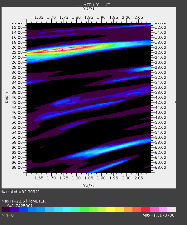
| Estimated Moho Depth: |
20.5 km |
| Estimated Crust Vp/Vs: |
1.74 |
| Assumed Crust Vp: |
6.276 km/s |
| Estimated Crust Vs: |
3.602 km/s |
| Estimated Crust Poisson's Ratio: |
0.25 |
|
| Radial Match: |
82.30921 % |
| Radial Bump: |
400 |
| Transverse Match: |
68.84788 % |
| Transverse Bump: |
400 |
| SOD ConfigId: |
2341311 |
| Insert Time: |
2017-10-04 18:14:05.404 +0000 |
| GWidth: |
2.5 |
| Max Bumps: |
400 |
| Tol: |
0.001 |
|

Signal To Noise
| Channel | StoN | STA | LTA |
| UU:MTPU:01:HHZ:20170920T16:48:34.688008Z | 10.519195 | 6.58665E-8 | 6.2615535E-9 |
| UU:MTPU:01:HHN:20170920T16:48:34.688008Z | 1.9928765 | 1.9567747E-8 | 9.818845E-9 |
| UU:MTPU:01:HHE:20170920T16:48:34.688008Z | 4.016642 | 1.5682637E-8 | 3.904415E-9 |
| Arrivals |
| Ps | 2.5 SECOND |
| PpPs | 8.7 SECOND |
| PsPs/PpSs | 11 SECOND |


