You are here: Home > Network List > UU - University of Utah Regional Network Stations List
> Station SPU South Promontory Point, UT, USA > Earthquake Result Viewer
SPU South Promontory Point, UT, USA - Earthquake Result Viewer
| Earthquake location: |
Off East Coast Of Honshu, Japan |
| Earthquake latitude/longitude: |
38.0/144.7 |
| Earthquake time(UTC): |
2017/09/20 (263) 16:37:16 GMT |
| Earthquake Depth: |
10 km |
| Earthquake Magnitude: |
6.1 Mww |
| Earthquake Catalog/Contributor: |
NEIC PDE/us |
|
| Network: |
UU University of Utah Regional Network |
| Station: |
SPU South Promontory Point, UT, USA |
| Lat/Lon: |
41.31 N/112.45 W |
| Elevation: |
2086 m |
|
| Distance: |
74.3 deg |
| Az: |
49.711 deg |
| Baz: |
306.86 deg |
| Ray Param: |
0.05241402 |
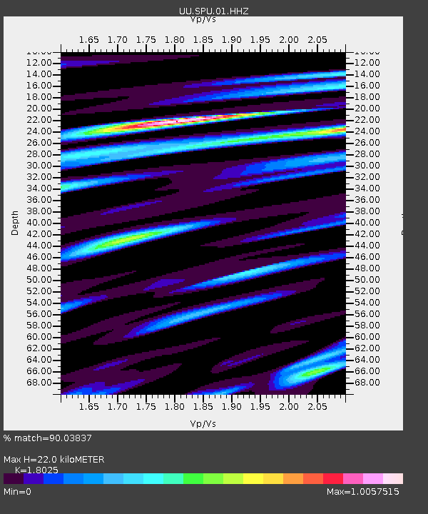
| Estimated Moho Depth: |
22.0 km |
| Estimated Crust Vp/Vs: |
1.80 |
| Assumed Crust Vp: |
6.276 km/s |
| Estimated Crust Vs: |
3.482 km/s |
| Estimated Crust Poisson's Ratio: |
0.28 |
|
| Radial Match: |
90.03837 % |
| Radial Bump: |
400 |
| Transverse Match: |
78.48325 % |
| Transverse Bump: |
400 |
| SOD ConfigId: |
2341311 |
| Insert Time: |
2017-10-04 18:14:15.057 +0000 |
| GWidth: |
2.5 |
| Max Bumps: |
400 |
| Tol: |
0.001 |
|

Signal To Noise
| Channel | StoN | STA | LTA |
| UU:SPU:01:HHZ:20170920T16:48:22.435017Z | 14.851796 | 6.0951486E-8 | 4.1039807E-9 |
| UU:SPU:01:HHN:20170920T16:48:22.435017Z | 3.626927 | 1.3666907E-8 | 3.768178E-9 |
| UU:SPU:01:HHE:20170920T16:48:22.435017Z | 3.8648605 | 2.3401439E-8 | 6.054925E-9 |
| Arrivals |
| Ps | 2.9 SECOND |
| PpPs | 9.5 SECOND |
| PsPs/PpSs | 12 SECOND |


