You are here: Home > Network List > TX - Texas Seismological Network Stations List
> Station ALPN Alpine > Earthquake Result Viewer
ALPN Alpine - Earthquake Result Viewer
| Earthquake location: |
Off East Coast Of Honshu, Japan |
| Earthquake latitude/longitude: |
38.0/144.7 |
| Earthquake time(UTC): |
2017/09/20 (263) 16:37:16 GMT |
| Earthquake Depth: |
10 km |
| Earthquake Magnitude: |
6.1 Mww |
| Earthquake Catalog/Contributor: |
NEIC PDE/us |
|
| Network: |
TX Texas Seismological Network |
| Station: |
ALPN Alpine |
| Lat/Lon: |
30.37 N/103.64 W |
| Elevation: |
1368 m |
|
| Distance: |
86.8 deg |
| Az: |
53.54 deg |
| Baz: |
312.659 deg |
| Ray Param: |
0.043791894 |
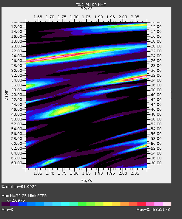
| Estimated Moho Depth: |
32.25 km |
| Estimated Crust Vp/Vs: |
2.10 |
| Assumed Crust Vp: |
6.121 km/s |
| Estimated Crust Vs: |
2.918 km/s |
| Estimated Crust Poisson's Ratio: |
0.35 |
|
| Radial Match: |
91.0922 % |
| Radial Bump: |
370 |
| Transverse Match: |
62.04262 % |
| Transverse Bump: |
395 |
| SOD ConfigId: |
2341311 |
| Insert Time: |
2017-10-04 18:15:36.803 +0000 |
| GWidth: |
2.5 |
| Max Bumps: |
400 |
| Tol: |
0.001 |
|

Signal To Noise
| Channel | StoN | STA | LTA |
| TX:ALPN:00:HHZ:20170920T16:49:29.065022Z | 13.604493 | 1.2649605E-6 | 9.298108E-8 |
| TX:ALPN:00:HH1:20170920T16:49:29.065022Z | 1.6106509 | 1.6364332E-7 | 1.0160074E-7 |
| TX:ALPN:00:HH2:20170920T16:49:29.065022Z | 6.229917 | 5.710175E-7 | 9.165733E-8 |
| Arrivals |
| Ps | 5.9 SECOND |
| PpPs | 16 SECOND |
| PsPs/PpSs | 22 SECOND |


