You are here: Home > Network List > TX - Texas Seismological Network Stations List
> Station SN04 Snyder 4 > Earthquake Result Viewer
SN04 Snyder 4 - Earthquake Result Viewer
| Earthquake location: |
Off East Coast Of Honshu, Japan |
| Earthquake latitude/longitude: |
38.0/144.7 |
| Earthquake time(UTC): |
2017/09/20 (263) 16:37:16 GMT |
| Earthquake Depth: |
10 km |
| Earthquake Magnitude: |
6.1 Mww |
| Earthquake Catalog/Contributor: |
NEIC PDE/us |
|
| Network: |
TX Texas Seismological Network |
| Station: |
SN04 Snyder 4 |
| Lat/Lon: |
32.90 N/100.87 W |
| Elevation: |
716 m |
|
| Distance: |
86.8 deg |
| Az: |
50.084 deg |
| Baz: |
313.912 deg |
| Ray Param: |
0.04379609 |
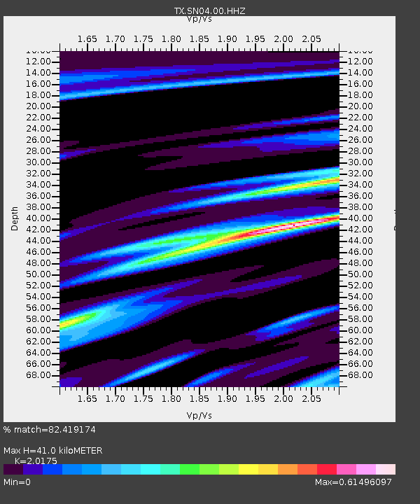
| Estimated Moho Depth: |
41.0 km |
| Estimated Crust Vp/Vs: |
2.02 |
| Assumed Crust Vp: |
6.426 km/s |
| Estimated Crust Vs: |
3.185 km/s |
| Estimated Crust Poisson's Ratio: |
0.34 |
|
| Radial Match: |
82.419174 % |
| Radial Bump: |
299 |
| Transverse Match: |
74.9254 % |
| Transverse Bump: |
331 |
| SOD ConfigId: |
2341311 |
| Insert Time: |
2017-10-04 18:16:30.963 +0000 |
| GWidth: |
2.5 |
| Max Bumps: |
400 |
| Tol: |
0.001 |
|

Signal To Noise
| Channel | StoN | STA | LTA |
| TX:SN04:00:HHZ:20170920T16:49:29.039998Z | 17.45286 | 1.7211719E-6 | 9.861833E-8 |
| TX:SN04:00:HH1:20170920T16:49:29.039998Z | 1.7919316 | 1.6843032E-7 | 9.399372E-8 |
| TX:SN04:00:HH2:20170920T16:49:29.039998Z | 4.4004946 | 5.730202E-7 | 1.3021723E-7 |
| Arrivals |
| Ps | 6.6 SECOND |
| PpPs | 19 SECOND |
| PsPs/PpSs | 25 SECOND |


