You are here: Home > Network List > AU - Australian Seismological Centre Stations List
> Station PSAB1 Pilbara Seismic Array Element B1 > Earthquake Result Viewer
PSAB1 Pilbara Seismic Array Element B1 - Earthquake Result Viewer
| Earthquake location: |
Vanuatu Islands |
| Earthquake latitude/longitude: |
-18.8/169.1 |
| Earthquake time(UTC): |
2017/09/20 (263) 20:09:49 GMT |
| Earthquake Depth: |
200 km |
| Earthquake Magnitude: |
6.4 mww |
| Earthquake Catalog/Contributor: |
NEIC PDE/us |
|
| Network: |
AU Australian Seismological Centre |
| Station: |
PSAB1 Pilbara Seismic Array Element B1 |
| Lat/Lon: |
21.57 S/119.82 E |
| Elevation: |
317 m |
|
| Distance: |
46.2 deg |
| Az: |
257.862 deg |
| Baz: |
95.745 deg |
| Ray Param: |
0.0700394 |
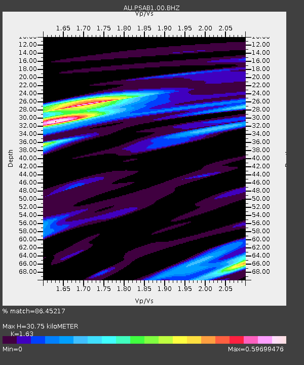
| Estimated Moho Depth: |
30.75 km |
| Estimated Crust Vp/Vs: |
1.63 |
| Assumed Crust Vp: |
6.464 km/s |
| Estimated Crust Vs: |
3.965 km/s |
| Estimated Crust Poisson's Ratio: |
0.20 |
|
| Radial Match: |
86.45217 % |
| Radial Bump: |
254 |
| Transverse Match: |
59.39284 % |
| Transverse Bump: |
400 |
| SOD ConfigId: |
2341311 |
| Insert Time: |
2017-10-04 20:59:19.919 +0000 |
| GWidth: |
2.5 |
| Max Bumps: |
400 |
| Tol: |
0.001 |
|

Signal To Noise
| Channel | StoN | STA | LTA |
| AU:PSAB1:00:BHZ:20170920T20:17:23.86899Z | 4.9269295 | 1.9228257E-6 | 3.9026858E-7 |
| AU:PSAB1:00:BH1:20170920T20:17:23.86899Z | 8.332396 | 1.2281226E-6 | 1.4739129E-7 |
| AU:PSAB1:00:BH2:20170920T20:17:23.86899Z | 0.9669713 | 2.0080185E-7 | 2.0766062E-7 |
| Arrivals |
| Ps | 3.2 SECOND |
| PpPs | 12 SECOND |
| PsPs/PpSs | 15 SECOND |


