You are here: Home > Network List > IU - Global Seismograph Network (GSN - IRIS/USGS) Stations List
> Station PMG Port Moresby, New Guinea > Earthquake Result Viewer
PMG Port Moresby, New Guinea - Earthquake Result Viewer
| Earthquake location: |
Fox Islands, Aleutian Islands |
| Earthquake latitude/longitude: |
52.8/-168.3 |
| Earthquake time(UTC): |
2020/12/01 (336) 16:22:40 GMT |
| Earthquake Depth: |
23 km |
| Earthquake Magnitude: |
6.3 mww |
| Earthquake Catalog/Contributor: |
NEIC PDE/us |
|
| Network: |
IU Global Seismograph Network (GSN - IRIS/USGS) |
| Station: |
PMG Port Moresby, New Guinea |
| Lat/Lon: |
9.40 S/147.16 E |
| Elevation: |
90 m |
|
| Distance: |
72.7 deg |
| Az: |
226.456 deg |
| Baz: |
26.465 deg |
| Ray Param: |
0.05348691 |
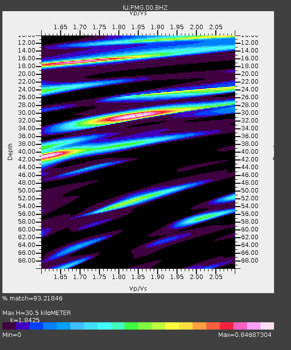
| Estimated Moho Depth: |
30.5 km |
| Estimated Crust Vp/Vs: |
1.84 |
| Assumed Crust Vp: |
6.122 km/s |
| Estimated Crust Vs: |
3.323 km/s |
| Estimated Crust Poisson's Ratio: |
0.29 |
|
| Radial Match: |
93.21846 % |
| Radial Bump: |
400 |
| Transverse Match: |
83.79208 % |
| Transverse Bump: |
400 |
| SOD ConfigId: |
23341671 |
| Insert Time: |
2020-12-15 17:31:41.640 +0000 |
| GWidth: |
2.5 |
| Max Bumps: |
400 |
| Tol: |
0.001 |
|
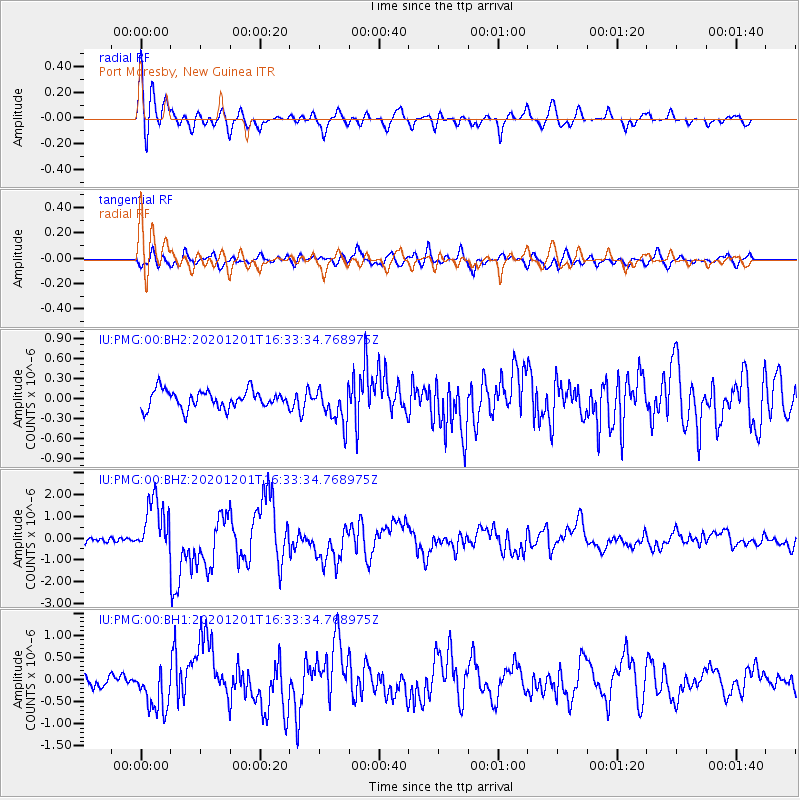
Signal To Noise
| Channel | StoN | STA | LTA |
| IU:PMG:00:BHZ:20201201T16:33:34.768975Z | 11.324032 | 1.2891019E-6 | 1.13837714E-7 |
| IU:PMG:00:BH1:20201201T16:33:34.768975Z | 3.8230824 | 5.109828E-7 | 1.3365728E-7 |
| IU:PMG:00:BH2:20201201T16:33:34.768975Z | 2.0114555 | 2.671737E-7 | 1.3282607E-7 |
| Arrivals |
| Ps | 4.3 SECOND |
| PpPs | 14 SECOND |
| PsPs/PpSs | 18 SECOND |


