You are here: Home > Network List > G - GEOSCOPE Stations List
> Station PPTF Pamatai - Papeete - Tahiti island - French Polynesia, France > Earthquake Result Viewer
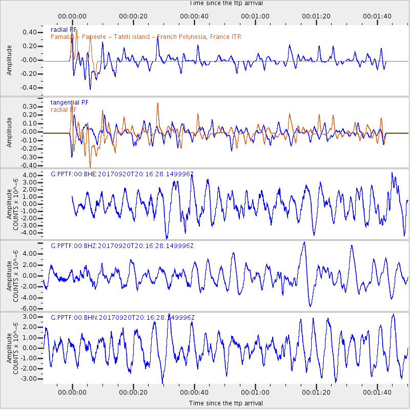
PPTF Pamatai - Papeete - Tahiti island - French Polynesia, France - Earthquake Result Viewer
*The percent match for this event was below the threshold and hence no stack was calculated.
| Earthquake location: |
Vanuatu Islands |
| Earthquake latitude/longitude: |
-18.8/169.1 |
| Earthquake time(UTC): |
2017/09/20 (263) 20:09:49 GMT |
| Earthquake Depth: |
200 km |
| Earthquake Magnitude: |
6.4 mww |
| Earthquake Catalog/Contributor: |
NEIC PDE/us |
|
| Network: |
G GEOSCOPE |
| Station: |
PPTF Pamatai - Papeete - Tahiti island - French Polynesia, France |
| Lat/Lon: |
17.59 S/149.57 W |
| Elevation: |
705 m |
|
| Distance: |
39.2 deg |
| Az: |
95.004 deg |
| Baz: |
261.647 deg |
| Ray Param: |
$rayparam |
*The percent match for this event was below the threshold and hence was not used in the summary stack. |
|
| Radial Match: |
50.149036 % |
| Radial Bump: |
400 |
| Transverse Match: |
51.49984 % |
| Transverse Bump: |
400 |
| SOD ConfigId: |
2341311 |
| Insert Time: |
2017-10-04 21:00:19.817 +0000 |
| GWidth: |
2.5 |
| Max Bumps: |
400 |
| Tol: |
0.001 |
|
Signal To Noise
| Channel | StoN | STA | LTA |
| G:PPTF:00:BHZ:20170920T20:16:28.149996Z | 0.91088897 | 8.4481917E-7 | 9.2746666E-7 |
| G:PPTF:00:BHN:20170920T20:16:28.149996Z | 0.5805269 | 8.585406E-7 | 1.4788989E-6 |
| G:PPTF:00:BHE:20170920T20:16:28.149996Z | 2.5797818 | 2.648908E-6 | 1.0267954E-6 |
| Arrivals |
| Ps | |
| PpPs | |
| PsPs/PpSs | |


