You are here: Home > Network List > PS - Pacific21 Stations List
> Station PSI Parapat, Indonesia > Earthquake Result Viewer
PSI Parapat, Indonesia - Earthquake Result Viewer
| Earthquake location: |
Fox Islands, Aleutian Islands |
| Earthquake latitude/longitude: |
52.8/-168.3 |
| Earthquake time(UTC): |
2020/12/01 (336) 16:22:40 GMT |
| Earthquake Depth: |
23 km |
| Earthquake Magnitude: |
6.3 mww |
| Earthquake Catalog/Contributor: |
NEIC PDE/us |
|
| Network: |
PS Pacific21 |
| Station: |
PSI Parapat, Indonesia |
| Lat/Lon: |
2.69 N/98.92 E |
| Elevation: |
987 m |
|
| Distance: |
89.5 deg |
| Az: |
273.821 deg |
| Baz: |
37.299 deg |
| Ray Param: |
0.041747306 |
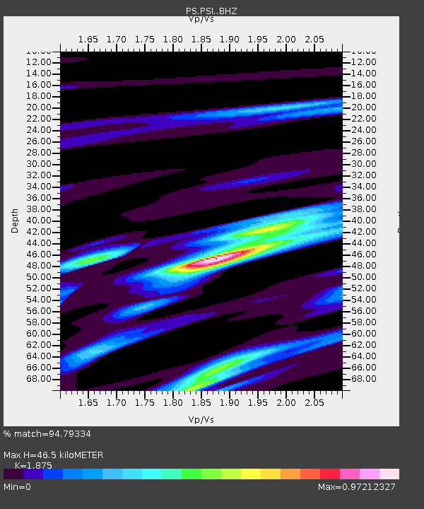
| Estimated Moho Depth: |
46.5 km |
| Estimated Crust Vp/Vs: |
1.88 |
| Assumed Crust Vp: |
6.468 km/s |
| Estimated Crust Vs: |
3.449 km/s |
| Estimated Crust Poisson's Ratio: |
0.30 |
|
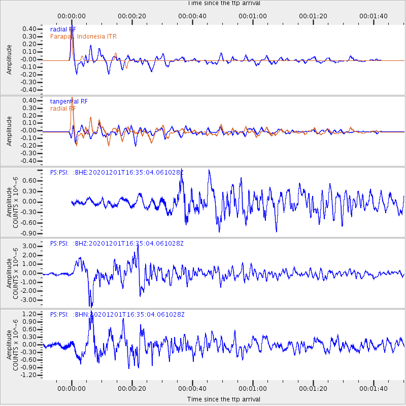
| Radial Match: |
94.79334 % |
| Radial Bump: |
397 |
| Transverse Match: |
88.58774 % |
| Transverse Bump: |
400 |
| SOD ConfigId: |
23341671 |
| Insert Time: |
2020-12-15 17:40:02.948 +0000 |
| GWidth: |
2.5 |
| Max Bumps: |
400 |
| Tol: |
0.001 |
|
Signal To Noise
| Channel | StoN | STA | LTA |
| PS:PSI: :BHZ:20201201T16:35:04.061028Z | 15.141838 | 9.809272E-7 | 6.478257E-8 |
| PS:PSI: :BHN:20201201T16:35:04.061028Z | 4.2187595 | 3.210238E-7 | 7.609436E-8 |
| PS:PSI: :BHE:20201201T16:35:04.061028Z | 2.0444827 | 1.9065725E-7 | 9.325452E-8 |
| Arrivals |
| Ps | 6.4 SECOND |
| PpPs | 20 SECOND |
| PsPs/PpSs | 27 SECOND |


