You are here: Home > Network List > CI - Caltech Regional Seismic Network Stations List
> Station BAR Barrett, Tecate, CA, USA > Earthquake Result Viewer
BAR Barrett, Tecate, CA, USA - Earthquake Result Viewer
| Earthquake location: |
South Of Alaska |
| Earthquake latitude/longitude: |
53.7/-150.6 |
| Earthquake time(UTC): |
2020/12/01 (336) 16:35:48 GMT |
| Earthquake Depth: |
10 km |
| Earthquake Magnitude: |
5.7 Mww |
| Earthquake Catalog/Contributor: |
NEIC PDE/us |
|
| Network: |
CI Caltech Regional Seismic Network |
| Station: |
BAR Barrett, Tecate, CA, USA |
| Lat/Lon: |
32.68 N/116.67 W |
| Elevation: |
521 m |
|
| Distance: |
32.0 deg |
| Az: |
117.326 deg |
| Baz: |
321.212 deg |
| Ray Param: |
0.078862146 |
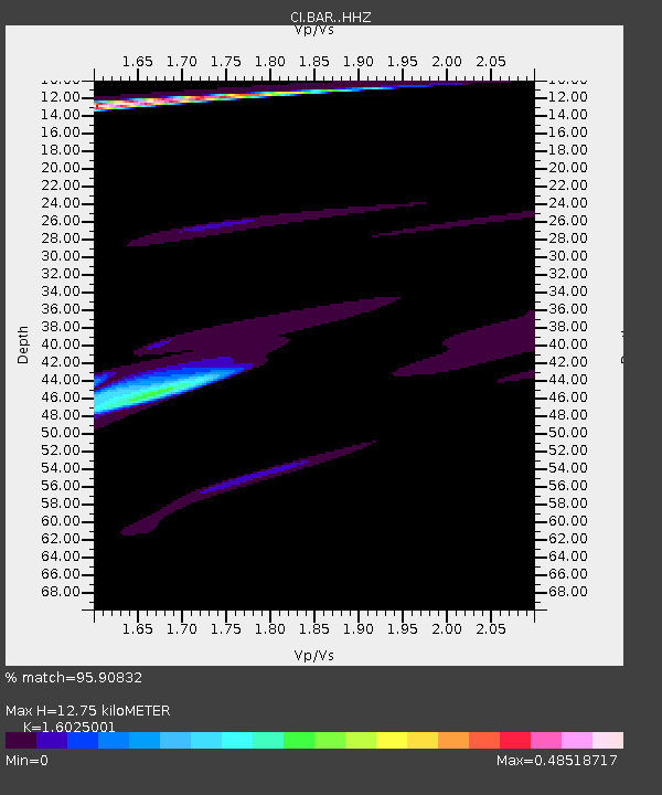
| Estimated Moho Depth: |
12.75 km |
| Estimated Crust Vp/Vs: |
1.60 |
| Assumed Crust Vp: |
6.264 km/s |
| Estimated Crust Vs: |
3.909 km/s |
| Estimated Crust Poisson's Ratio: |
0.18 |
|
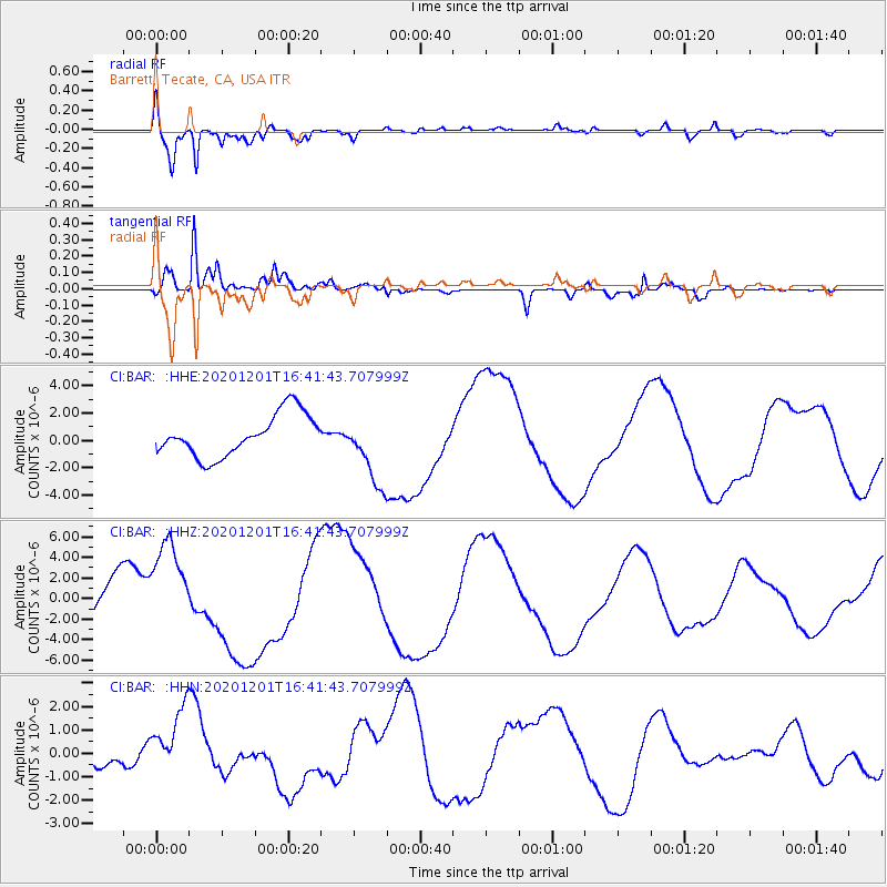
| Radial Match: |
95.90832 % |
| Radial Bump: |
400 |
| Transverse Match: |
83.63958 % |
| Transverse Bump: |
400 |
| SOD ConfigId: |
23341671 |
| Insert Time: |
2020-12-15 17:47:35.967 +0000 |
| GWidth: |
2.5 |
| Max Bumps: |
400 |
| Tol: |
0.001 |
|
Signal To Noise
| Channel | StoN | STA | LTA |
| CI:BAR: :HHZ:20201201T16:41:43.707999Z | 2.876183 | 4.492076E-6 | 1.5618186E-6 |
| CI:BAR: :HHN:20201201T16:41:43.707999Z | 1.7813538 | 1.4512959E-6 | 8.147151E-7 |
| CI:BAR: :HHE:20201201T16:41:43.707999Z | 1.7094351 | 2.60982E-6 | 1.5267149E-6 |
| Arrivals |
| Ps | 1.3 SECOND |
| PpPs | 4.9 SECOND |
| PsPs/PpSs | 6.2 SECOND |


