You are here: Home > Network List > IW - Intermountain West Stations List
> Station MOOW Moose Ponds, Wyoming, USA > Earthquake Result Viewer
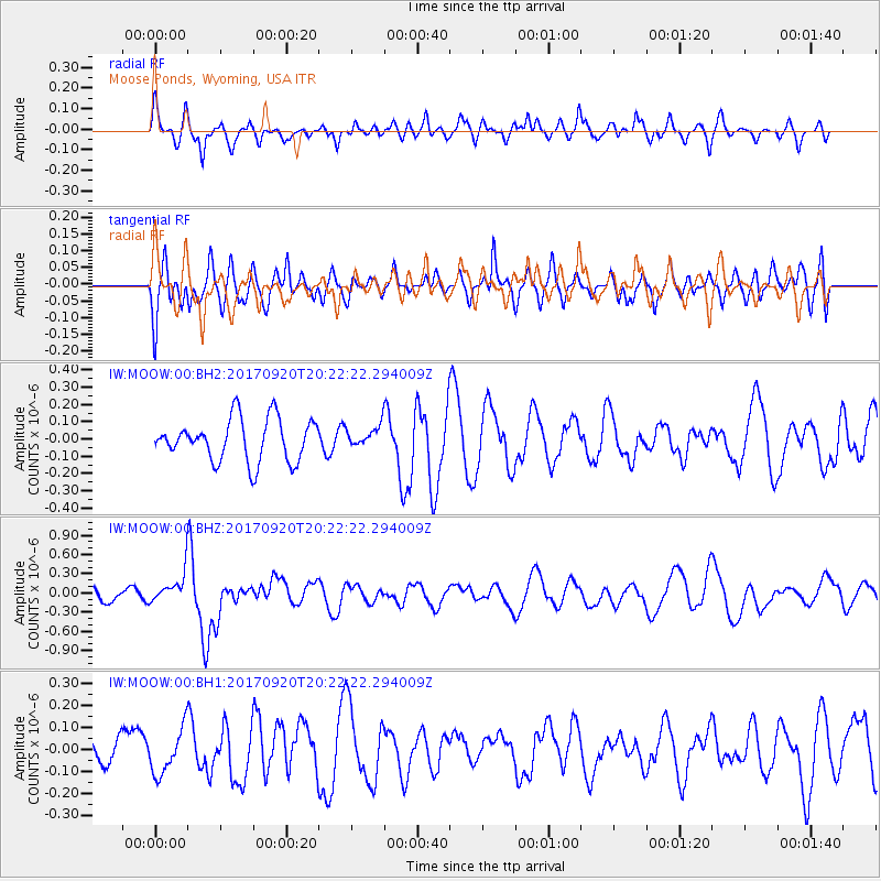
MOOW Moose Ponds, Wyoming, USA - Earthquake Result Viewer
*The percent match for this event was below the threshold and hence no stack was calculated.
| Earthquake location: |
Vanuatu Islands |
| Earthquake latitude/longitude: |
-18.8/169.1 |
| Earthquake time(UTC): |
2017/09/20 (263) 20:09:49 GMT |
| Earthquake Depth: |
200 km |
| Earthquake Magnitude: |
6.4 mww |
| Earthquake Catalog/Contributor: |
NEIC PDE/us |
|
| Network: |
IW Intermountain West |
| Station: |
MOOW Moose Ponds, Wyoming, USA |
| Lat/Lon: |
43.75 N/110.74 W |
| Elevation: |
2128 m |
|
| Distance: |
95.9 deg |
| Az: |
45.88 deg |
| Baz: |
249.787 deg |
| Ray Param: |
$rayparam |
*The percent match for this event was below the threshold and hence was not used in the summary stack. |
|
| Radial Match: |
33.283607 % |
| Radial Bump: |
385 |
| Transverse Match: |
52.278965 % |
| Transverse Bump: |
400 |
| SOD ConfigId: |
2341311 |
| Insert Time: |
2017-10-04 21:01:43.418 +0000 |
| GWidth: |
2.5 |
| Max Bumps: |
400 |
| Tol: |
0.001 |
|
Signal To Noise
| Channel | StoN | STA | LTA |
| IW:MOOW:00:BHZ:20170920T20:22:22.294009Z | 2.0505738 | 2.3339096E-7 | 1.1381739E-7 |
| IW:MOOW:00:BH1:20170920T20:22:22.294009Z | 1.2131139 | 1.02069194E-7 | 8.413818E-8 |
| IW:MOOW:00:BH2:20170920T20:22:22.294009Z | 0.4956452 | 6.044218E-8 | 1.2194647E-7 |
| Arrivals |
| Ps | |
| PpPs | |
| PsPs/PpSs | |


