You are here: Home > Network List > PY - PFO Array Stations List
> Station BPH05 Pinon Flat Observatory, CA, USA > Earthquake Result Viewer
BPH05 Pinon Flat Observatory, CA, USA - Earthquake Result Viewer
| Earthquake location: |
South Of Alaska |
| Earthquake latitude/longitude: |
53.7/-150.6 |
| Earthquake time(UTC): |
2020/12/01 (336) 16:35:48 GMT |
| Earthquake Depth: |
10 km |
| Earthquake Magnitude: |
5.7 Mww |
| Earthquake Catalog/Contributor: |
NEIC PDE/us |
|
| Network: |
PY PFO Array |
| Station: |
BPH05 Pinon Flat Observatory, CA, USA |
| Lat/Lon: |
33.61 N/116.46 W |
| Elevation: |
1302 m |
|
| Distance: |
31.4 deg |
| Az: |
115.936 deg |
| Baz: |
320.147 deg |
| Ray Param: |
0.07909869 |
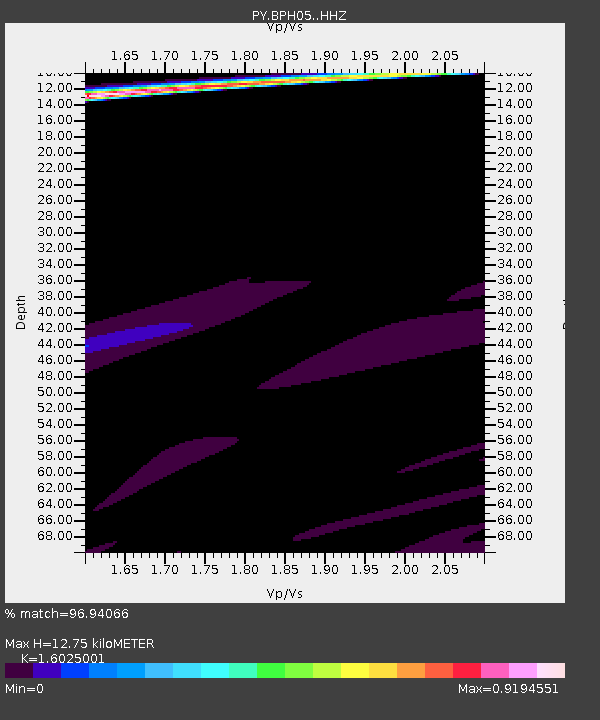
| Estimated Moho Depth: |
12.75 km |
| Estimated Crust Vp/Vs: |
1.60 |
| Assumed Crust Vp: |
6.264 km/s |
| Estimated Crust Vs: |
3.909 km/s |
| Estimated Crust Poisson's Ratio: |
0.18 |
|
| Radial Match: |
96.94066 % |
| Radial Bump: |
259 |
| Transverse Match: |
81.865814 % |
| Transverse Bump: |
400 |
| SOD ConfigId: |
23341671 |
| Insert Time: |
2020-12-15 17:57:19.569 +0000 |
| GWidth: |
2.5 |
| Max Bumps: |
400 |
| Tol: |
0.001 |
|

Signal To Noise
| Channel | StoN | STA | LTA |
| PY:BPH05: :HHZ:20201201T16:41:38.411001Z | 0.9685873 | 2.1760795E-6 | 2.2466531E-6 |
| PY:BPH05: :HHN:20201201T16:41:38.411001Z | 1.94523 | 1.1059515E-6 | 5.685454E-7 |
| PY:BPH05: :HHE:20201201T16:41:38.411001Z | 3.1947618 | 3.9560045E-6 | 1.2382784E-6 |
| Arrivals |
| Ps | 1.3 SECOND |
| PpPs | 4.9 SECOND |
| PsPs/PpSs | 6.2 SECOND |


